Collection of data to characterise key geological elements of region
| Date: | Tuesday, 11 October 2016 |
|---|
Valuable geological data about the structure and evolution of Earth’s crust in the Kimberley region and across northern Australia will soon be collected through an airborne gravity survey in the eastern Kimberley area.
The Kimberley Gravity Project, which began last week, aims to collect gravity data by conducting an airborne gravity survey to help characterise key geological elements of the region.
The collaborative work is being undertaken by the Geological Survey of Western Australia (GSWA), a division of the Department of Mines and Petroleum (DMP), and its partner Geoscience Australia (GA), a division of the Commonwealth Department of Industry, Innovation and Science.
GSWA Director of Mapping, Dr Ian Tyler, said the project area of about 48 000 km² extended from Medusa Banks in the north to Halls Creek in the South.
“The aim of the project is improve our understanding of the geological formations across the Kimberley region and northern Australia,” he said.
“Gravity data can help geoscientists to ‘see’ features that are beneath the surface and can give a 3D view of the geological structure of a region.”
The project is one of a range of GSWA’s multi-disciplinary, ground and airborne projects spread throughout Western Australia, including the Pilbara, the Gascoyne, the Mid-West and the Eastern Goldfields.
The surveys map the geology of the State for use in exploration for minerals, petroleum and groundwater, agricultural land assessments, and geo-hazards monitoring.
Survey maps and geology publications also contribute to geotourism attractions associated with the iconic Kimberley landscape.
Dr Tyler said the data generated from the survey would eventually be made publicly available at no cost from the DMP and GA websites after processing of the field data has been completed.
Data acquired will be used by GSWA geoscientists to complement other field geological mapping and sampling programs being carried out in the Kimberley region.
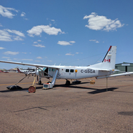
Sander Geophysics Limited (SGL) has been contracted to conduct the survey to measure changes in the earth’s gravity field caused by variations in the density of the underlying rocks.
SGL field manager Ms Angella Farr, said the gravity measurements were being made with AIRGrav, which is a very sensitive gravity meter developed by SGL specifically for airborne operations.
"For this survey, the gravity meter, together with proprietary high-resolution navigation equipment, are mounted in a Cessna 208B Grand Caravan aircraft flying at a height of 160m above the ground along lines 2.5 km apart,” Ms Farr said.
“An airborne survey of this type and configuration can be completed quickly with no disturbance to residents or disruption to activities in the region.”
The survey aircraft and crew of six people includes the field manager, a processing geophysicist, pilots and an aircraft maintenance engineer.
The crew will be based out of Kununurra for the duration of the survey which is expected to be two or three months.
Monitoring geophysicists from GSWA or GA may also visit the project for short periods during the survey.
Questions about the general nature and objectives of regional geophysical surveys may be directed to GSWA by email to geophysics@dmp.wa.gov.au or to Geoscience Australia on telephone 1800 091 964 (free call).
For all operational information and queries about the Sander Geophysics aircraft movements, please contact Ms Angella Farr, Field Manager, Sander Geophysics Limited by email to sglaustralia@sgl.com or telephone on 0499 691 063.
Information about GSWA mapping projects is available on line at www.dmp.wa.gov.au/gswa.
Information about GA projects is available online at www.ga.gov.au.