DMP has developed a land access guide for the areas immediately surrounding the Black Diamond pit lake.
| Date: | Thursday, 22 December 2016 |
|---|
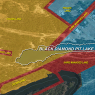
A map outlining the land tenure boundaries around the Black Diamond pit lake has been developed by the Department of Mines and Petroleum (DMP) to raise public awareness of land use in the area.
Sarah Bellamy, Manager Environmental Reform said the new guide distinguishes between private land, Crown land and Shire managed land.
“DMP has no ownership or management responsibilities for Black Diamond and the surrounding land, however we recognise the importance of ensuring members of the public are clear on the do’s and don’ts in the area, as well as the land access restrictions. We hope the map will provide clarity for people who want to use the land for recreational purposes.” she said.
Black Diamond is located within the Allanson town site boundary approximately 5km west of Collie and was officially declared an abandoned mine site under Section 9 of the Mining Rehabilitation Fund Act 2012 (MRF Act) on Friday 9 September 2016. It was the first of four pilot sites to be rehabilitated as part of the DMP’s Abandoned Mines Program.
The land tenure boundaries map can be accessed online and for information relating to the recent rehabilitation works at Black Diamond, including a case study of the rehabilitation project, please visit our website.
Alternatively, please email the Abandoned Mines Team abandonedmines@dmp.wa.gov.au or phone +61 8 9222 3162.