Thursday 17 December 2014 after 0900 AWST (UTC +8)
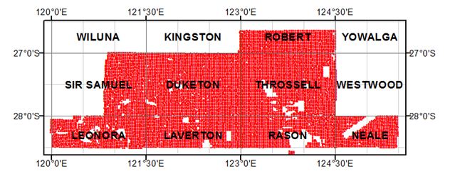
Sir Samuel — Throssell 2014 gravity survey — final data
Final data from the regional ground gravity survey (2.5 km grid) completed in September 2014 will 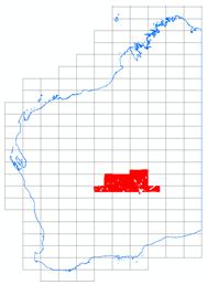 be available from the GSWA website on the Latest Geophysical Surveys page at www.dmp.wa.gov.au/geophysics.
Point-located (‘vector’) data and grids can be downloaded free of charge from the Geophysical Archive Data Delivery System (GADDS) or purchased on disk from Geoscience Australia.
Most recent geophysical data releases
Date Survey Data status
16 Sep 2014 WA Magnetic anomaly grids (80 m; 40m) 2014 – v1
21 Aug 2014 Goldfields area 20 m grid compilations v1
26 Jun 2014 Kalgoorlie East 2013 airborne mag/rad survey (R70822) Final
26 Jun 2014 Kurnalpi North 2013 airborne mag/rad survey (R70849) Final
26 Jun 2014 Kurnalpi South 2013 airborne mag/rad survey (R70850) Final
26 Jun 2014 Capricorn 2013 reconnaissance AEM survey (R70825) Final
Access to previously released geophysical data
Image data from previous geophysical releases can be found on our Regional Geophysical Surveys page. Digital located and grid data can be purchased on media from Geoscience Australia or downloaded free of charge through the Geophysical Archive Data Delivery System (GADDS).
DMP’s new eBookshop released
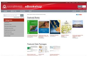 The Department of Mines and Petroleum’s (DMP) eBookshop has been transformed and is now live. This replaces the existing eBookshop. The new updated eBookshop application is a completely new system, which is hosted by an external provider.
Although GSWA has produced almost 5000 products including books, maps and digital products, only maps, USB data packages, and nine premium publications are available to purchase in ‘hard’ format. A new online cart and payment system is in place. Records, Reports, Bulletins and other non-series books cannot be purchased in hard copy but are all available as PDFs to view and download from both the eBookshop and using the Geoscience publications tab accessed by the Online systems button on DMP’s Home page.
The new eBookshop interface is colourful, shows thumbnails of all products for easy navigation, and the landing page can be updated with new products for display.
The link from the DMP website to access eBookshop remains the same: www.dmp.wa.gov.au/ebookshop .
1:500 000 State interpreted bedrock geology of Western Australia, 2014
Base layer to provide more information for explorers
 A new Statewide seamless Interpreted Bedrock Geology digital map at a very useable 1:500 000 scale was released on 2 December by Mines and Petroleum Minister Bill Marmion.
The digital map will form the base layer for some Geological Survey of Western Australia (GSWA) maps and spatial products which will give explorers a consistent new summary of the geology of Western Australia. It is also the base layer for many of the Department of Mines and Petroleum’s (DMP) spatial databases.
The up-to-date framework will provide a more accurate backdrop for regional ground selection.
GSWA Executive Director Rick Rogerson said as well as being more accurate spatially, more information about each map unit is included than ever before.
‘This will provide a whole wealth of additional information which will be of great assistance to explorers and geologists,’ he said.
The 1:500 000 interpreted bedrock geology map is a complete reinterpretation and update based on GSWA mapping since 2000, the culmination of a decade’s work and understanding of the geology of Western Australia.
‘It is a set of intelligent spatial layers, rather than a single map and includes interpreted bedrock faults and folds, and areas of significant Cenozoic deposits, a separate layer of rocks less than 65 million years old,’ Dr Rogerson said.
‘The layers aim to illustrate the regional geological framework of Western Australia in as much detail as possible at this scale, rather than being simply a standalone map.’
The lookup table for the main interpreted bedrock geology layer is coarsely sorted using tectonic subdivisions first and then age, providing the digital equivalent of a map legend.
‘As well, the recent geophysical datasets acquired as part of the State Government’s Exploration Incentive Scheme (EIS) have been extensively used in generating the map,’ Dr Rogerson said.
Updates are already planned and will be released incrementally as more information becomes available.
Spatial layers at 1:2 500 000 scale, including geological polygons, structures and tectonic divisions, are the next product which will result in a new, completely revised State Geological Map — the first since 1998, and the first compiled entirely digitally.
At the launch, Minister Marmion said the map highlighted the State Government’s commitment to WA’s world-leading resource industry.
The 1:500 000 scale layers and associated lookup tables are available as a download from the Data and Software Centre.
Once there, go to Statewide Spatial Datasets, then Geology, then 1:500 000 Interpreted Bedrock Geology, then Download the product.
Christmas discount — Devonian Reef Complexes for $50!
Bulletin 145 Devonian Reef Complexes of the Canning Basin by Phillip E Playford, Roger M Hocking, and Anthony E Cockbain
The Devonian reef complexes form a spectacular belt of rugged limestone ranges that extend for 350 kilometres along the northern edge of Western Australia's Canning Basin. 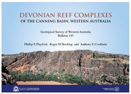 These complexes are regarded as the world's best example of an exposed ancient barrier reef system, and have become known as the Devonian Great Barrier Reef.
The rocks are prospective for both zinc-lead deposits and petroleum, and are regarded as a model for similar reefs that host prolific oilfields elsewhere in the world.
How to purchase
This publication is now available at the low price of $50 (including GST). To purchase a hard copy, please email bookshop@dmp.wa.gov.au . You can also download a free PDF.
Database training dates released for 2015 — sign up now
The Geological Survey of Western Australia (GSWA) offers FREE training in its databases and online systems. The training is in the form of a presentation with hands-on interaction in most systems.
Topics include:
- navigating the Department of Mines and Petroleum’s (DMP) website
- searching for geoscience publications
- finding digital datasets using the Data and Software Centre
- searching for open-file mineral exploration reports using WAMEX
- searching the mineral drillholes and geochemistry databases
- bringing it all together with the interactive map viewer, GeoVIEW.WA and using GeoMap.WA, a standalone GIS viewer for Windows.
Participants are welcome to bring their own laptops for individual instruction; however, a desktop computer will be available for the training.
Sessions for 2015
PERTH
The Perth training has been divided into separate sessions: one for prospectors, and one for mining companies/geologists.
Venue: Mineral House, 100 Plain Street, East Perth
- Thursday 5 March
- Thursday 11 June
- Thursday 29 October
KALGOORLIE
The Kalgoorlie training is open to all.
Venue: Room 102 (computer lab), Goldfields Institute of Technology, Centre for Engineering and Mining Training (CEMT), Australian Prospectors and Miners Hall of Fame, Kalgoorlie
- Thursday 12 March
- Thursday 18 June
- Thursday 5 November
More information can be found here.
To register, email your details to publications@dmp.wa.gov.au.
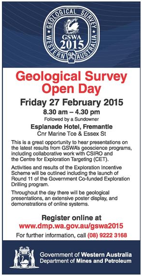
GSWA Open Day 2015 — Friday 27 February 2015
Latest releases
NON-SERIES BOOKS
GSWA calendar 2015
Stepping stones — self-guided walks
NON-SERIES DIGITAL PRODUCTS
1:500 000 State interpreted bedrock geology of Western Australia, 2014
Go to link above, then Statewide Spatial Datasets, then Geology, then 1:500 000 Interpreted Bedrock Geology, then Download.
Subscribe to Fieldnotes
 Fieldnotes is a quarterly publication released by GSWA to provide the State's exploration industry and other geoscientists with an update on our latest work and ongoing programs. The publication provides updates on other GSWA products and services and is available free from the Information Centre located on the first floor of Mineral House, 100 Plain Street, East Perth 6004. Find past issues of Fieldnotes here or subscribe to receive a hard copy by emailing publications@dmp.wa.gov.au.
Access GSWA products
You can download maps, reports, and digital information free of charge from our website.
Click on these links to take you to the download page for that product:
- Geoscience information, maps and reports
- GIS versions of maps
- Interactive geological map (GeoVIEW.WA)
- Promotional flyers and posters
- GeoMap.WA GIS software
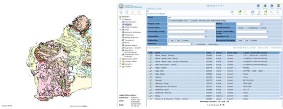
- Mineral deposits and mine information (MINEDEX)
- Mineral exploration reports (WAMEX)
- Petroleum and geothermal information (WAPIMS)
- TENGRAPH online
- Airborne geophysics index (MAGIX)
- Geochronology
- Geochemistry (GeoChem Extract)
- Petroleum Geothermal Register (PGR)
Hard copies
Maps, USB data packages, and nine premium publications are available to purchase as hard copies from the eBookshop or the First Floor counter at Mineral House, 100 Plain Street, East Perth WA 6004. A new online cart and payment system is in place. Records, Reports, Bulletins and other non-series books cannot be purchased in hard copy but are all available as PDFs to view and download.
Contact us

For information on publications, email publications@dmp.wa.gov.au
or telephone +61 8 9222 3459/ fax +61 8 9222 3444.
For information on digital data, email the Digital Data Administrator on gsd.dda@dmp.wa.gov.au or telephone +61 8 9222 3816.
Physical address
Mineral House
100 Plain Street
East Perth WA 6004
www.dmp.wa.gov.au/gswa
For more information about GSWA and its products, go to our website.