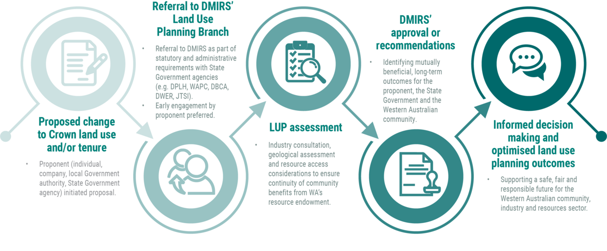
The Land Use Planning Branch (LUP) helps to shape and inform land use planning policy and outcomes by providing advice based on geoscience, resource mapping and prospectivity assessments. On behalf of the Minister for Mines and Petroleum, LUP also holds an approval role for changes to Crown land tenure.
Early Engagement
The Branch collaborates with other government departments such as the Departments of Planning, Lands and Heritage, Premier and Cabinet, Biodiversity, Conservation and Attractions and Jobs, Tourism, Science and Innovation, as well as Local Government Authorities (LGAs) to assist with land use decisions and managing impacts arising from land use/tenure changes.
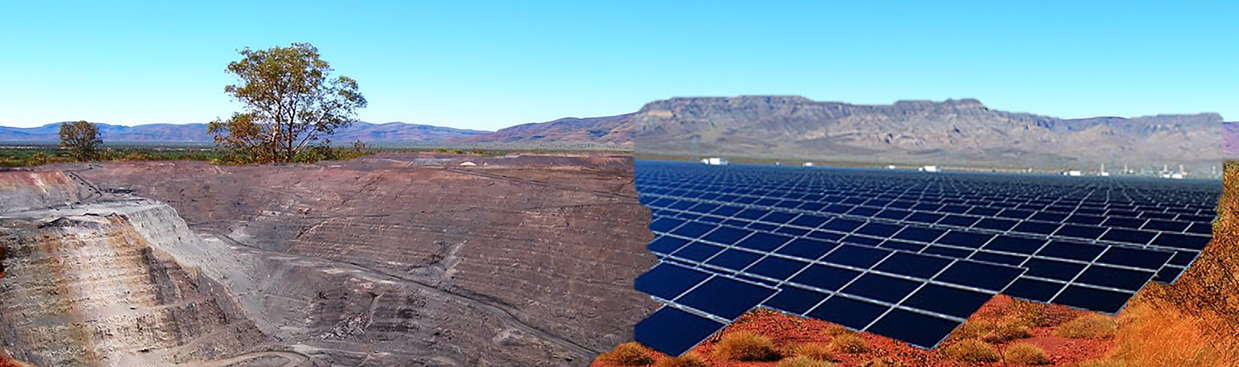
LUP aims to maintain access for exploration and development of the State’s mineral, basic raw material, petroleum and geothermal energy resources while assisting with the delivery of State land use objectives. Input is also provided into strategic and statutory planning matters, including policy advice on resources.
Early engagement regarding proposed land use/tenure change ensures informed decision making and provides opportunities to optimise land use planning by identifying mutually beneficial, long-term outcomes for the proponent, the State Government and the Western Australian community.
Core Functions
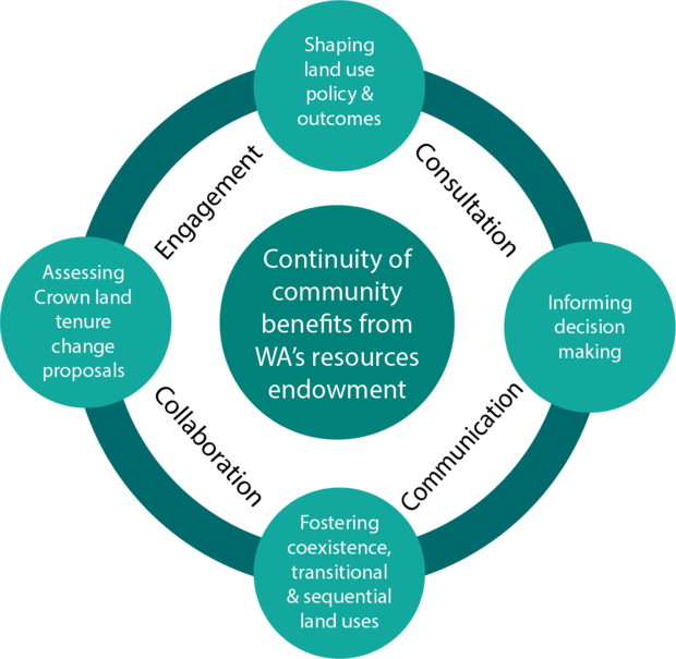
Access to mineral and energy resources can be impacted by land use/tenure changes. LUP’s purpose is to ensure the continuity of community benefits from Western Australia’s resources endowment. This is underpinned by our core functions:
- shaping land use policy and outcomes through engagement and collaboration with government agencies and LGAs;
- informing decision making by providing advice and geoscientific resource mapping data to government, LGAs, industry and the public;
- fostering coexistence, transitional and sequential land uses, particularly around townsite planning and rural land use; and
- assessing proposals (including industry referrals) and providing approvals/recommendations for proposed land tenure and land use changes throughout the State.
When assessing land use/tenure changes, some of the key considerations include:
- using geoscientific information to establish prospectivity and help maintain access to valuable mineral, petroleum and basic raw materials as well as areas needed for future exploration;
- State Planning Policies - ensure proposed planning strategies, schemes and structure plans, take into account responsible long-term supply of Basic Raw Materials and strategic minerals (e.g. battery metals, critical minerals, Titanium-Zircon, etc.);
- coexistence with mineral and energy resources including transitional and sequential land uses, particularly around rural land use and during townsite planning; and
- avoiding unnecessary sterilisation of mineral and energy resources from incompatible land uses, such as subdivision and development proposals, scheme amendments (rezoning), planning strategies, structure plans, land management plans and infrastructure proposals.
Key Legislation
LUP’s considerations and assessment are also based on the requirements of relevant legislation such as:
- Mining Act 1978
- Petroleum and Geothermal Energy Resources Act 1967
- Petroleum Pipelines Act 1969
- Land Administration Act 1997
- Planning and Development Act 2005
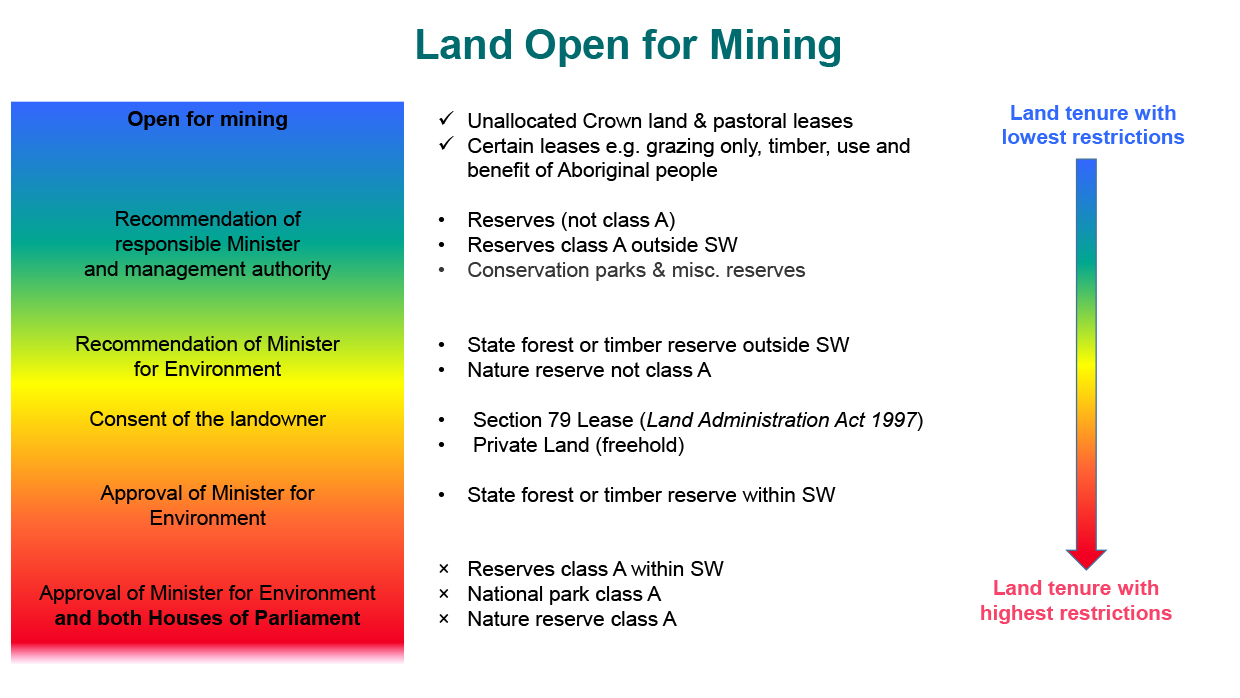
Generally, the key legislation prescribes access to mineral and energy resources according to the current land tenure and/or land use. Future access to mineral and energy resources can be substantially reduced by changes to land tenure and/or land use. Some changes to land tenure invalidate existing resource access consents and require the proponent to gain new approvals before onsite activities can continue.
Key Projects
In addition to day-to-day core business LUP provides input into significant and State priority projects. Recent examples include:
- Native Title Settlement Agreements
- Plan for Our Parks
- Spatial database of Basic Raw Materials and Titanium-Zircon Mineral Resources.
Basic Raw Materials
Basic Raw Materials (BRM) are essential for the construction of buildings, roads and other infrastructure as well as for agricultural production. Therefore the identification and responsible extraction of BRM is critical in ensuring continuing supply to support development and agriculture in the State.
LUP provides spatial data and information regarding BRM resources to ensure its importance at both local and regional levels is identified at the earliest stages and utilised efficiently through the planning and development processes of government’s land use planning.
For further information see Basic Raw Materials.
Spatial Information Tools and Links
DMIRS has a range of publicly accessible systems and resources. State agencies, LGAs and proponents involved in land use planning, land management and administration are encouraged to utilise these to aid in decision making.
- Tengraph Web is a spatial enquiry and mapping system displaying the position of Western Australian mining tenements and petroleum titles in relation to other land information.
- GeoVIEW.WA is an interactive (GIS-based) mapping system. Users can construct geological maps and incorporate other mineral and petroleum exploration datasets including mines and mineral deposits, petroleum wells, active leases and much more. Resources around townsites and along the Swan Coast Plain can be viewed by selecting layers under ‘Land Use planning’ in the Layers table of contents.
File Notation Areas
Land tenure change proposals assessed by DMIRS are represented as a File Notation Area (FNA) and displayed in both Tengraph Web and GeoVIEW.WA. These FNAs are critical to land use planning as they inform stakeholders of proposed land tenure changes that may affect access to their land interests. These can be viewed by selecting File Notations Areas under ‘Special Category Land’ in the Layers table of contents.
The Special Category Land layer also contains additional information about land tenure that may impact on resource access, such as Aboriginal Heritage Areas and environmental considerations.
Contact Information
For general enquires please email: landuseplanning@dmirs.wa.gov.au.
To provide information to LUP or seek feedback and advice about your proposals, strategies and schemes please email: IMSoperations@dmirs.wa.gov.au - Attention Land Use Planning