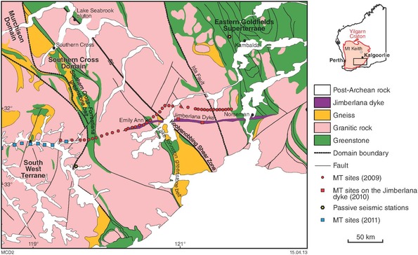
A 300 km long MT survey comprising 56 stations was completed across the southern Yilgarn Craton during three campaigns in 2009–11. The survey was conducted along an east–west traverse extending from the South West Terrane, across the Southern Cross Domain (Youanmi Terrane), and on to the Kalgoorlie Terrane (Eastern Goldfields Superterrane).
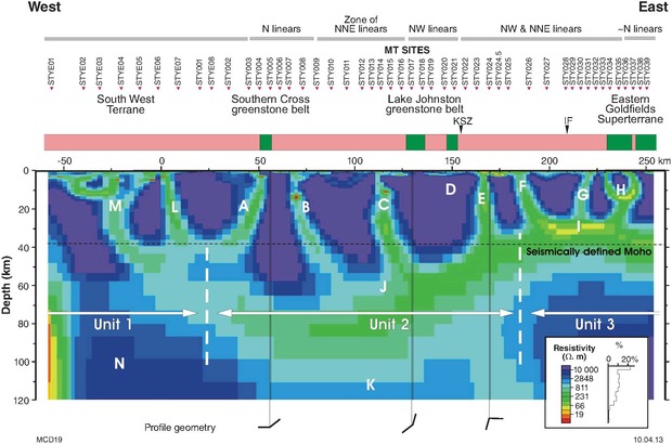
The MT survey confirmed a three-fold subdivision of the local lithosphere, consistent with the geologically and geochemically defined terranes and domains in this part of the Yilgarn Craton. The central unit, interpreted as equivalent to the Southern Cross Domain of the Youanmi Terrane, has a resistive crust overlying a more conductive mantle. The unit to the east comprises a conductive lower crust overlying a resistive mantle. The eastern margin of the Southern Cross Domain, as inferred from deep crustal and mantle resistivity, lies about 50 km to the west of the Ida Fault mapped at the surface. The western unit has a resistive crust overlying a resistive mantle and is correlated with the South West Terrane.
The survey demonstrates that the MT method is a viable means of mapping the deep-crustal and mantle structure of the Yilgarn Craton. All MT data are now available for download from the Airborne Geophysics Index (MAGIX) layers using the GSWA interactive map-viewing application GeoVIEW.WA.
Details of the Southern Cross MT traverse and its interpretation are available in Report 121 A magnetotelluric traverse across the southern Yilgarn Craton.
Contact
For more information contact:
geological.survey@dmirs.wa.gov.au