Deep crustal survey program paints picture below Earth’s surface
| Date: | Tuesday, 24 October 2023 |
|---|
The Geological Survey of Western Australia (GSWA) is currently undertaking a geoscientific investigation into the architecture, structural features and geological domains of the Earth’s crust in the southwest corner of Western Australia. The data will also help understand the origin of the seismicity and earthquakes in this part of the State.
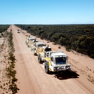
HiSeis, a specialist company in seismic acquisition studies, is conducting 1200km of deep crustal 2D seismic reflection surveys along three lines. The first and longest line of approximately 630km is in the South West and began in mid-September near Cascade. Three specialised vibroseis trucks are moving westward towards the end of the line at Hamelin Bay north of Augusta. It is expected that the line will be completed in early November.
The second and third lines are located in the Mid West. One line will be from Mount Magnet towards Geraldton (350km) and is planned for completion before the end of February 2024. The third line located 200km south of Geraldton is planned for mid-2024.
Deep crustal seismic surveying is a low impact, non-invasive geophysical technique, using artificially generated sound wave vibrations from the trucks. The data recorded is used to create images of the crust to depths of 40–50 km.