Information from 2018 survey available for download.
| Date: | Monday, 15 April 2019 |
|---|
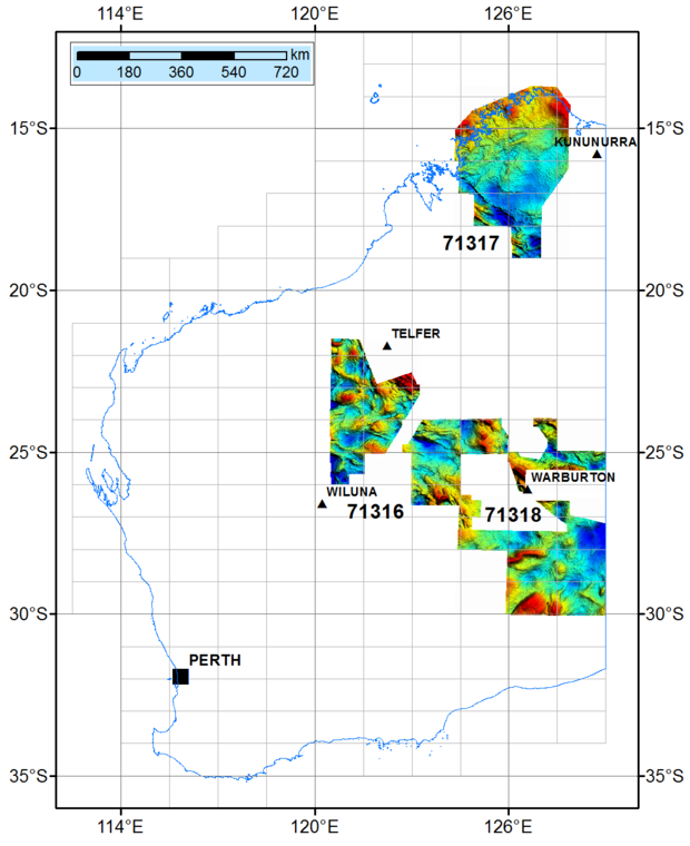
The latest airborne gravity data from three surveys over large tracts of the Kimberley Basin, and the Little Sandy and Great Victoria Desert areas is now available on the Department of Mines, Industry Regulation and Safety’s (DMIRS) website.

Covering 440,000 square kilometres, the surveys are part of a seven-year collaborative program between the Geological Survey of Western Australia (GSWA), a division of DMIRS, and Geoscience Australia (GA), a division of the Commonwealth Department of Industry, Innovation and Science.
GSWA Geoscience Director Dr Ian Tyler said that the program, scheduled to end in 2020, would mark the completion of a new generation of regional gravity coverage of Western Australia, with data providing critical information in the understanding of key geological elements across the State.
The data was collected in the latter part of 2018 by Sander Geophysics Limited, using its proprietary AIRGrav system.
It is now accessible to the public at no cost on the DMIRS website through GSWA’s interactive mapping application, GeoVIEW.WA, and on GA’s website.
“GSWA has been acquiring data from airborne geophysical surveys since the mid-1980s and we’ve been doing airborne geophysical studies in our own right since 1993, so this is a long-running standard approach to regional mapping,” Dr Tyler said.
“We’ve been conducting airborne gravity surveys since 2016. They are faster than ground surveys and avoid the need for ground access in areas that are remote and logistically difficult.”
The Kimberley area in the north is a target for gold, copper, diamonds, nickel, vanadium, titanium and other base metals, while the eastern blocks of the Little Sandy and Great Victoria Deserts may have potential for oil and gas, and nickel, platinum and copper.
“By systematically mapping the geology and geophysics of the State in this way, GSWA and GA provide public data that helps to de-risk the area for future mineral and petroleum exploration, and can be used by companies to assess Western Australia as a preferred destination for investment,” Dr Tyler said.
Further information about the department’s geoscientific projects is available at: www.dmirs.wa.gov.au/gswa
More information about GA projects is available at: www.ga.gov.au

