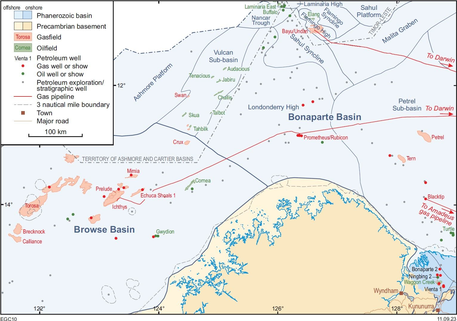
The Bonaparte Basin, the most northerly sedimentary basin in Western Australia, straddles the Northern Territory – Western Australia border and contains a Paleozoic to Cenozoic sedimentary succession up to 17 km thick. The entirely Paleozoic southern onshore part covers about 20 000 km2 whereas offshore the overlying Mesozoic succession thickens to the north where the basin covers over 250 000 km2, almost entirely under Commonwealth or Northern Territory jurisdiction.
Geological setting
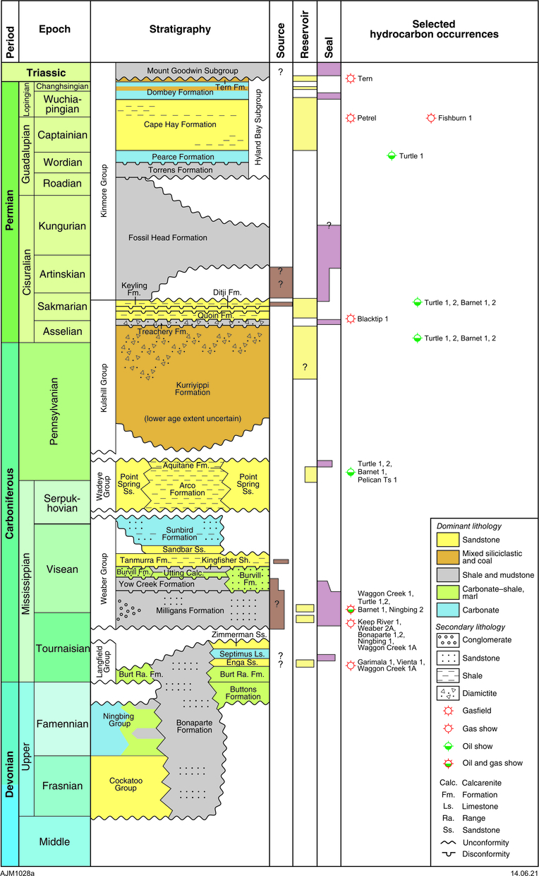
The southern onshore part of the basin onlaps onto, or is faulted against, Proterozoic rocks. The dominant structural element of the southernmost and central offshore part of the basin is the north-northwesterly trending Petrel Sub-basin that developed as a v-shaped rift during the Devonian to Early Carboniferous. Overall, the succession becomes younger to the north, with only Cambrian – lower Permian strata present onshore.
The three main periods of deposition evident onshore are: Cambrian–Ordovician, which is only known onshore; Late Devonian to Early Carboniferous, which represents the remnants of a rift system controlled by numerous north-northwesterly oriented normal faults; and Late Carboniferous to Permian, when siliciclastic sediments encroached onto the earlier rift blocks and onlapped Proterozoic rocks, forming the flanking shelves. Offshore, salt diapirs disrupt Devonian and younger strata but the age of the evaporitic succession from which they originate is uncertain and seemingly absent onshore.
The northern offshore part of the basin is dominated by northeast-trending fault blocks associated with younger rifting events of which the Late Jurassic breakup event is the most significant. Although no wells reach below the Upper Permian, seismic data reveal an even older section and rare salt structures similar to those at the southern end of the Petrel Sub-basin. The north-northwest structural trends in this sub-basin pre-date mid-Permian – Mesozoic rifting along the margin of the Australian Craton, that was close to perpendicular to the structural trends within the northern sub-basins of the basin (the Ashmore and Sahul Platforms, Vulcan Sub-basin, Londonderry High, and Malita Graben). That rifting thereby exerted little structural influence across the Petrel Sub-basin and onshore parts of the basin.
In the Cenozoic, thick shelfal carbonates prograded across the entire western margin of Australia, including the Bonaparte Basin. The mid-Miocene collision with the Indonesian Plate to the north rejuvenated faults and produced small anticlines.
Exploration history
Petroleum exploration of the Bonaparte Basin commenced with onshore reconnaissance of outcrops in the late 1940s. Since the drilling of the first well in the basin, Bonaparte 1 in 1963 in the onshore Western Australian portion of the basin, there have been over 350 offshore wells compared to 15 onshore, of which nine were in Western Australia. In the waters under Commonwealth jurisdiction south of the area ceded to Timor-Leste and the Territory of the Ashmore and Cartier Islands, there have been more than 200 000 line-km of 2D and 19 000 km2 of 3D seismic surveys acquired. By comparison, about 1600 line-km of onshore 2D seismic data are available for the Western Australian portion of the basin.
Prospectivity
The offshore Bonaparte Basin is highly prospective, with over 40 oil and gas fields discovered to date, mostly in the north and northwest of the basin. The southeastern offshore part of the basin has also yielded several fields such as Blacktip, Petrel and Tern. Onshore gas accumulations indicate the possibility for economic hydrocarbons, but there are no developed fields. In addition, two wells had oil shows, as did many shallow mineral exploration drillholes along the edge of the basin. The Devonian–Carboniferous sedimentary succession is considered to have generated hydrocarbons from dark shale of the Lower Carboniferous Milligans Formation and the Upper Devonian Bonaparte Formation.
Potential shale plays and tight gas plays in the onshore Bonaparte Basin include shale gas from the lower Milligans Formation and tight gas sandstone and limestone reservoirs in the Langfield Group, but such plays remain untested; to date only sandstone reservoirs in Milligans Formation have successfully flowed gas.
Onshore Bonaparte Basin hydrocarbon shows
| Year | Discovery | Hydrocarbon type | Reservoir | Age of reservoir |
| 1963–64 | Bonaparte 1 & 2 | gas show | Milligans Formation | Lower Carboniferous |
| 1982 | Ningbing 1 | oil and gas show | Ningbing Group and Bonaparte Formation | Upper Devonian |
| 1988 | Garimala 1 | gas show | Milligans Formation and Bonaparte Formation | Lower Carboniferous |
| 1995 | Waggon Creek 1A | gas and oil show | Milligans Formation | Lower Carboniferous |
| 1998 | Vienta 1 | gas show | Milligans Formation and Ningbing Group | Lower Carboniferous and Upper Devonian |
GSWA publications
Further reading
Colwell JB and Kennard JM (compilers) 1996, Petrel Sub-basin study 1995–1996: Summary Report: Australian Geological Survey Organisation, Record 1996/40, 122p.
Leonard, AA, Vear, A, Panting, AL, de Ruig, MJ, Dunne, JC and Lewis, KA 2004, Blacktip-1 gas discovery: an AVO success in the southern Bonaparte Basin, Western Australia, in Timor Sea Petroleum Geoscience: Proceedings of the Timor Sea Symposium, 19–20 June, 2003 edited by GK Ellis, PW Baillie and TJ Munson: Northern Territory Geological Survey, Special Publication 1, p. 25–35.
Contact
For further information, contact:
basinenergy.geoscience@dmirs.wa.gov.au