The Phanerozoic Canning Basin is the State’s largest onshore basin covering over 795 000 km2 of which about 55 000 km2 lies offshore. The bulk of the onshore succession, which is up to 15 km thick, is Paleozoic. Much of the basin remains underexplored even though petroleum exploration has spanned more than a century.
Geological setting
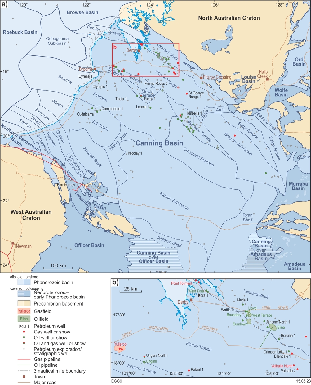
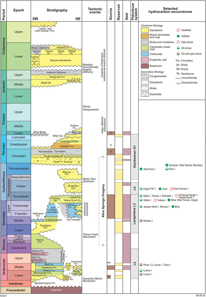
The Canning Basin developed as an intracratonic sag between the West and North Australian Cratons during the Early Paleozoic. The bulk of the sedimentary succession is Ordovician to Middle Triassic, mostly composed of continental to marine carbonate and clastic sedimentary facies, including widespread Upper Ordovician to Silurian evaporitic deposits. Upper Cambrian sections may be present in depocentres but remain unconfirmed by drilling. Overlying Jurassic to Cenozoic sedimentary deposits are thin, especially inland from the coast, but thicken markedly offshore towards the Roebuck Basin.
The main phases of significant tectonism producing much of the present structural configuration in the basin developed during:
- possible Cambrian to Silurian extension and rapid subsidence
- early Devonian compression and erosion (Prices Creek Movement)
- Middle Devonian to early Carboniferous extension and subsidence
- middle Carboniferous compression (Meda Transpression)
- late Carboniferous to early Triassic subsidence
- Middle Triassic to Middle Jurassic uplift and erosion (Fitzroy Transpression).
Apart from faulting, these events did not greatly deform strata within the basin, making them difficult to differentiate at a local scale. Younger strata are relatively thin, flat lying and only weakly indurated as subsequent structural events, such as the late phases of the breakup of Gondwana, barely affected the basin.
The basin contains a series of mostly west-northwesterly striking sub-basins. These tectonic divisions apply chiefly to the succession pre-dating the Meda Transpression; overlying strata show considerably less deformation. The main divisions are:
- Fitzroy Trough and Gregory Sub-basin, representing a Devonian–Triassic northern depocentre containing a Phanerozoic succession estimated at up to 15 km thick. Strata older than the Devonian may be present but have not been penetrated by drilling.
- Kidson and Willara Sub-basins, representing an Ordovician–Devonian southern depocentre, which is up to 5 km thick overlain by a thin Permo-Carboniferous and Mesozoic succession.
- Broome and Crossland Platforms, a central basement high containing an extensive Ordovician–Devonian succession overlain by thin Permo-Carboniferous sections.
- areas flanking the margins of the basin are designated as structural ‘shelves’, where pre-Permian strata either abut, thin or pinch out. A series of minor grabens and platforms contiguous with the Anketell Shelf fringe the southwestern margin of the basin and grade westwards into a similar shelf along the northern edge of the West Australian Craton; however, identification of these features relies on limited data.
Exploration history
Petroleum exploration began in the Canning Basin in the early 1920s when the Freney Kimberley Oil Company drilled four shallow wells following reports of oil shows in a water bore on the Lennard Shelf. Minor exploration continued until the 1950s when West Australian Petroleum Pty Ltd (WAPET) carried out regional seismic surveys and drilled 17 wells. Over the 1960s to 1980s, exploration intensified and included regional gravity, magnetic and seismic surveys, and outcrop mapping by the Bureau of Mineral Resources (BMR, now Geoscience Australia). Of the 340 onshore and six offshore (in Commonwealth Waters) wells drilled in the basin, 103 were stratigraphic, 214 were new field wildcats and 29 were development or extension wells. Onshore there have been over 360 seismic surveys (totalling over 90 000 km of 2D lines and six small 3D surveys that cover 1930 km2), with the most concentrated coverage along the southern margin of the Lennard Shelf, southern Fitzroy Trough and adjacent areas. Offshore, there have been 70 seismic surveys encompassing over 70 000 line-km.
Until the mid-1980s, exploration focused largely on the northern and central parts of the basin, with the primary exploration targets being Devonian, Carboniferous and Permian reservoirs. Whereas many wells encountered shows (particularly oil), few yielded commercial hydrocarbons. The first commercial discovery in the basin was in 1981 at Blina on the Lennard Shelf, followed soon after by the Sundown, Lloyd, Boundary, West Terrace and West Kora oilfields, and the Point Torment gas discovery in 1992. Significant oil and gas shows in subsalt Ordovician plays found during the 1980s and 1990s, such as Looma 1, Pictor 1 and Cudalgarra 1, have yet to lead to production.
A renewed phase of exploration began in 2006 that focused mainly on the Broome Platform, Jurgurra Terrace and Fitzroy Trough, and included the basin’s first 3D seismic survey in 2009. During this phase, renewed drilling by Buru Energy led to the recognition of the Laurel Formation basin-centred gas system (BCGS) in 2010 and discovery of the Ungani oilfield in 2011, also in the Laurel Formation. More recently, Buru Energy announced the 2021 discovery of the Rafael gas and condensate accumulation in the same reservoir.
Prospectivity
Ordovician, Devonian and Lower Carboniferous petroleum systems are considered the best prospects for liquid hydrocarbons with the latter (mostly the Laurel Formation) having sourced, for example, Devonian carbonate reservoirs of the Blina oilfield and Permo-Carboniferous siliciclastic reservoirs of the Boundary, Lloyd, Sundown, West Kora and West Terrace fields. In the Fitzroy Trough, Lower Carboniferous siliciclastic facies of the Laurel BCGS are also prospective for tight gas. Large parts of the Canning Basin remain poorly explored with relatively few wells drilled in much of the basin. In addition, only a small percentage of wells in the basin are considered valid structural tests.
Play types are geographically and stratigraphically variable. For example, fracture systems associated with transfer zones connect the Lennard Shelf to the Fitzroy Trough and control migration and permeability within carbonate and siliciclastic reservoirs. In contrast, lower Carboniferous siliciclastics within the Fitzroy Trough provide both source and reservoir for the Laurel BCGS play. The Fitzroy Trough and the sub-basins on its margins have long been considered the most prospective parts of the basin due to their thick sedimentary successions, reefal carbonate buildups and structural development. Shows in these areas confirm petroleum generation and migration. The basin also contains many untested plays such as unconformity, stratigraphic, downthrown rollover, inversion fold and subsalt traps, as well as reservoirs draped over rotated fault blocks.
In the southern Canning Basin, there is potential for oil and gas generation from Ordovician carbonaceous shale in the Goldwyer and upper Nambeet Formations. Potential conventional reservoirs include the Ordovician lower Nambeet and Nita Formations, Devonian carbonate and the Tandalgoo Formation, and the Permian Grant Group. In areas that lack major block faulting, salt diapirism may have generated traps. Ordovician subsalt discoveries in the Broome Platform and the Kidson Sub-basin demonstrate that mature, migrated oil from source rocks is present in the south of the basin. The recent drilling of stratigraphic well Barnicarndy 1 on the southwestern margin of the basin discovered a new Ordovician sandstone reservoir (Barnicarndy Formation) overlying a thick section of the Nambeet Formation but shales of the latter unit have minimal source potential at this location.
The Ordovician Goldwyer Formation and the Carboniferous Laurel Formation have potential for shale gas and oil with the latter estimated by the US Energy Information Administration in 2013 to contain 11.9 Tm3 (420 Tcf) gas in place with a risked recoverable resource of 0.53 Tm3 (18.9 Tcf). Whereas estimates of the former by US Energy Information Administration are considerable, they also make many assumptions that are not realistic. Recent tests of the Ordovician include Theia 1, Nicolay 1, Olympic 1, Cyrene 1 and Commodore 1. Of these, Theia 1 confirmed the presence of high total organic content shales with oil potential in an over-pressured zone of the lower Goldwyer Formation on the Broome Platform.
GSWA publications
-
 GSWA Report 222
The Cobb Embayment: Ordovician syntectonic siliciclastic deposition
GSWA Report 222
The Cobb Embayment: Ordovician syntectonic siliciclastic deposition
-
 GSWA Report 211
Reference section, revised stratigraphy and facies analysis — Nambeet Formation
GSWA Report 211
Reference section, revised stratigraphy and facies analysis — Nambeet Formation
-
 GSWA Report 207
Mid-Carboniferous – Lower Permian palynology and stratigraphy, Canning Basin, Western Australia
GSWA Report 207
Mid-Carboniferous – Lower Permian palynology and stratigraphy, Canning Basin, Western Australia
-
 GSWA Report 182
2017 Canning Basin SEEBASE study and GIS data package
GSWA Report 182
2017 Canning Basin SEEBASE study and GIS data package
-
 2017 Canning Basin SEEBASE study
GIS data package
2017 Canning Basin SEEBASE study
GIS data package
-
 GSWA Report 169
Petroleum source potential of the Ordovician Nambeet Formation, Canning Basin
GSWA Report 169
Petroleum source potential of the Ordovician Nambeet Formation, Canning Basin
-
 GSWA Record 2017/5
Canning Coastal seismic survey — an overview of the Canning Basin
GSWA Record 2017/5
Canning Coastal seismic survey — an overview of the Canning Basin
-
 GSWA Report 140
Regional structural and stratigraphic study of the Canning Basin, Western Australia
GSWA Report 140
Regional structural and stratigraphic study of the Canning Basin, Western Australia
-
 GSWA Report 140 data package
Regional structural and stratigraphic study of the Canning Basin, Western Australia
GSWA Report 140 data package
Regional structural and stratigraphic study of the Canning Basin, Western Australia
-
 GSWA Report 124
Petroleum geochemistry and petroleum systems modelling of the Canning Basin, Western Australia
GSWA Report 124
Petroleum geochemistry and petroleum systems modelling of the Canning Basin, Western Australia
-
 GSWA Report 105
The Carribuddy Group and Worral Formation, Canning Basin, Western Australia
GSWA Report 105
The Carribuddy Group and Worral Formation, Canning Basin, Western Australia
-
 GSWA Record 2004/7
Depositional facies and regional correlations of the Ordovician Goldwyer and Nita Formations, Canning Basin
GSWA Record 2004/7
Depositional facies and regional correlations of the Ordovician Goldwyer and Nita Formations, Canning Basin
Further reading
Normore, L, Haines, PW, Carr, LK, Henson, P, Zhan, Y, Wingate, MTD, Zhen, YY, Lu, Y, Martin, S, Kelsey, D, Allen, H and Fielding, I 2021, Barnicarndy Graben, southern Canning Basin: stratigraphy defined by the Barnicarndy 1 stratigraphic well: The APPEA Journal, v. 61, no. 1, p. 224–235, doi:10.1071/AJ20160.
Purcell, PG (Editor) 1984, The Canning Basin, WA: Proceedings of the Geological Society of Australia/Petroleum Exploration Society of Australia Symposium, Perth, 19–27 June, 1984.
US Energy Information Administration 2013, Technically Recoverable Shale Oil and Shale Gas Resources: An Assessment of 137 Shale Formations in 41 Countries Outside the United States: US Energy Information Administration, www.eia.gov/analysis/studies/worldshalegas/pdf/overview.pdf.
Contact
For further information, contact:
basinenergy.geoscience@dmirs.wa.gov.au