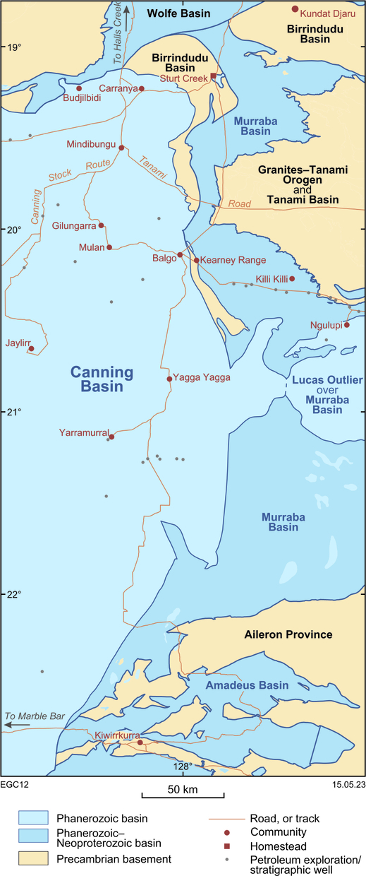
The Murraba Basin is exposed, or lies beneath shallow cover, over about 26 000 km2 in central-north Australia, straddling the border with the Northern Territory, of which about 20 000 km2 is within Western Australia. The basin is part of the Centralian Superbasin and may extend west, at depth, beneath the northeast Canning Basin.
Geological setting
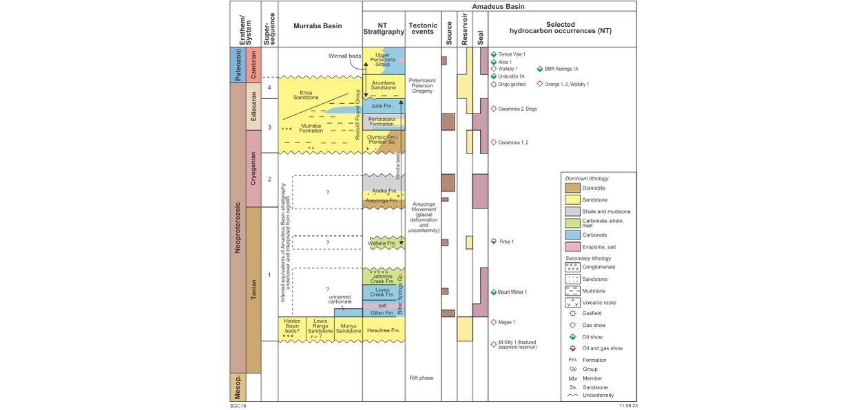
The term Murraba Basin was introduced in 2005 for the Neoproterozoic sedimentary succession previously included in the upper part of the Birrindudu Basin — that name is now restricted to strata of late Paleoproterozoic to early Mesoproterozoic age. Previously, the Neoproterozoic section was correlated with the basal succession (Supersequence 1) of the Neoproterozoic Centralian Superbasin. For this reason, and because outcrop is largely limited to sandstone, the basin was assumed to have no significant petroleum prospectivity. A recent reconnaissance outcrop study of the southern Murraba Basin has significantly revised the basin’s age through comparison to adjacent parts of the superbasin, requiring a reassessment of its prospectivity.
The Murraba Basin has a broadly similar stratigraphy and depositional history to the Neoproterozoic to lower Cambrian sedimentary succession within the Amadeus Basin, although meagre exposures mean some parts remain poorly understood given the lack of deep drilling. The basin unconformably overlies Paleoproterozoic basement rocks of the Aileron Province in the south, the Granites–Tanami Orogen and Tanami Basin in central areas, and the Birrindudu Basin in the north. Contacts with coeval basins — the Amadeus Basin in the south and Wolfe Basin in the north — are not exposed, but are inferred to be faulted. The Paleozoic–Mesozoic Canning Basin is in fault contact to the west and locally overlies the Murraba Basin. Strata in the basin are gently folded and faulted apart from local tight folds near major fault zones.
The basal succession of sandstone and conglomerate, which includes up to 400 m of Munyu Sandstone in the south, is interpreted as a direct correlative of the Heavitree Formation of the Amadeus Basin. The Lewis Range Sandstone in the north may be an equivalent, but could be younger. The overlying unnamed interval, inferred from limited outcrop of carbonate and extensive regolith containing carbonate clasts, is of significant, but uncertain, thickness. This interval is considered to be the equivalent of the upper Tonian Bitter Springs Group, and possibly the Wallara Formation, in the Amadeus Basin, which contains several potential source horizons and a widespread lower salt seal. The thick siliciclastic Hidden Basin beds in the southwest is no older than lower Tonian based on detrital zircon dating, but correlations to other units of this age are unclear.
Two Cryogenian glacial successions, locally separated by thick black shale with hydrocarbon source potential, are present elsewhere in the Centralian Superbasin (Areyonga, Aralka and Olympic Formations of the Amadeus Basin). The only evidence for these glacial–interglacial successions is possible basement-derived glacial erratics within the regolith overlying the carbonate-bearing interval.
The upper part of the basin, the redefined Redcliff Pound Group, comprises a broadly shallowing-upward succession of sandstone, siltstone, minor conglomerate and carbonate of shallow marine, deltaic and terrestrial (fluvial, eolian) origin, of inferred Ediacaran – early Cambrian age. Siliciclastic input in the upper part of this interval indicates uplift and erosion to the west likely related to early phases of the Petermann and partly coeval Paterson Orogenies. The main loci of these events were to the south and west, respectively, within the Amadeus, Officer and Yeneena Basins.
Much of the deformation in the Murraba Basin pre-dates Paleozoic deposition in the Canning Basin, probably in the early Cambrian during the final phase of the Petermann and Paterson Orogenies. However, structural events as young as Triassic clearly affected Permian strata along the eastern margin of the Canning Basin, and may also have affected the Murraba Basin, particularly along its western margin.
Exploration history
There has been no petroleum or geothermal exploration within the Murraba Basin although the Bureau of Mineral Resources (now Geoscience Australia) drilled a series of shallow stratigraphic holes across the northern part of the basin in 1974. There is no seismic data across the basin but a few Canning Basin lines just cross the faulted edge of the basin. Aeromagnetic and radiometric data (flown with 200–400 m line spacing) are available across all of the Western Australian part of the basin. A recent gravity survey covering the southern part of the basin and adjacent Canning Basin provides data at 2.5 km spacing, with lower resolution data available in the north.
Prospectivity
Poor outcrop, the paucity of seismic data and the lack of deep drilling render the basin’s prospectivity speculative. The similarity of the succession to the Neoproterozoic of the Amadeus Basin suggests equivalents to some of the petroleum systems in that basin may be present. With an estimated basin thickness greater than 2000 m in depocentres, maturation of source beds low in the succession (as in the Amadeus Basin) is feasible. The level of structural complexity and tectonic history is similar to the Amadeus Basin, suggesting a comparable variety of potential structural traps. In addition, indications of a halotectonic style for some surface structures suggest the presence of deep salt. If sufficiently thick, an equivalent to the subsalt, high-helium/hydrogen ‘Gillen petroleum system’ in the Amadeus Basin may be present. Ediacaran–Cambrian hydrocarbon systems, analogous to the Dingo gasfield of the Amadeus Basin, are unlikely due to insufficient burial and lack of an apparent seal in the upper part of the succession, except perhaps where the Murraba Basin is deeply buried below the Canning Basin.
Suggested reading
Haines, PW and Allen, H-J 2019, Hydrocarbon and helium prospectivity of the Amadeus and Murraba basins in Western Australia, in The sedimentary basins of Western Australia V: Proceedings of the West Australian Basins Symposium edited by M Keep and SJ Moss, Perth, Western Australia, 2–5 September 2019: Petroleum Exploration Society of Australia, 17p.
Contact
For further information, contact:
basinenergy.geoscience@dmirs.wa.gov.au