Northern Carnarvon Basin
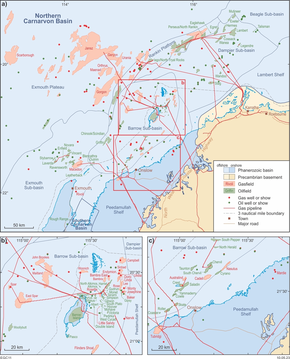
The Northern Carnarvon Basin covers about 500 000 km2, and mostly lies offshore. It extends north and east from the Pilbara region to the continental–oceanic crust boundary. The Northern Carnarvon Basin is transitional to, and overlies, the predominantly onshore Southern Carnarvon Basin. Several islands (e.g. Barrow Island, Airlie Island, Varanus Island and Thevenard Island) host oil and gas production facilities in the basin, and extend the State’s jurisdiction offshore by up to 98 km from the coast.
Barrow Island, which contains the Barrow Island oilfield, is the site of the Gorgon liquefied natural gas and domestic gas plant. All other operational plants are onshore. In 2017, the depleted Tubridgi gasfield 25 km west of Onslow became a gas storage facility. A project to sequester CO2 from the Gorgon gasfield beneath Barrow Island became operational in August 2019. About 7 Mt had been injected by November 2022 with 120 Mt planned over the estimated 40-year life of the project.
Geological setting
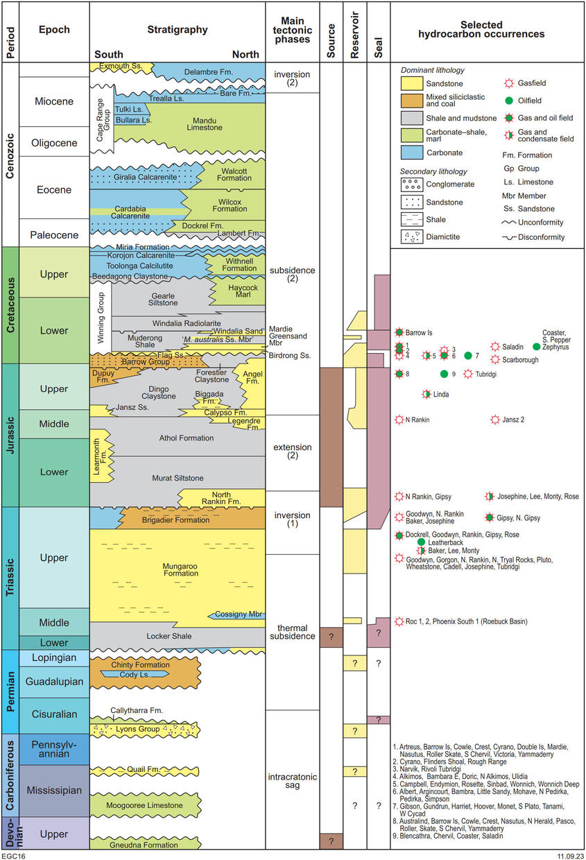
The Northern Carnarvon Basin is dominated by a southwest-trending set of major depocentres — the Exmouth, Barrow, Dampier and Beagle Sub-basins, which contain up to 15 km of Mesozoic sedimentary rocks. In these sub-basins, Mesozoic and Cenozoic successions overlie (commonly at considerable depth) Paleozoic sedimentary rocks. Shoreward of the depocentres are the Peedamullah Shelf and Lambert Shelf, which are flanked on the seaward side by a mid-basin arch consisting of the Rankin Platform and the Alpha Arch. The Kangaroo Trough, Dixon Sub-basin and Exmouth Plateau lie farther offshore.
The breakup of Gondwana (Late Jurassic to earliest Cretaceous) controlled the evolution of the Northern Carnarvon Basin. Prior to breakup, several sedimentary sequences were deposited in an elongate basin between Precambrian basement of the Pilbara region and continental blocks to the northwest. However, strata older than Triassic have been intersected in relatively few wells confined to the eastern margin of the basin so the early evolution of the basin is poorly known. At the end of the Paleozoic, rapidly subsiding, northeasterly trending troughs developed in the Northern Carnarvon Basin to form its present-day framework, followed by faulting and breakup in the Jurassic when thick siliciclastic sequences accumulated in offshore marine to continental settings. Final continental separation in the Early Neocomian was farther offshore than the aborted rifts along the axis of the Barrow and Dampier Sub-basins, resulting in a trailing edge, passive-margin basin. In the Late Cretaceous, global oceanic circulation patterns changed, allowing deposition to shift from siliciclastic to carbonate dominated, resulting in the progradation of thick carbonate deposits across the entire offshore basin.
Exploration history
In 1953, the first exploration well in the basin, Rough Range 1, discovered oil next to the eastern edge of the Exmouth Sub-basin. Follow-up discoveries of oil at Barrow Island (1964), and of gas in North Tryal Rocks 1 (1971), established the Northern Carnarvon Basin as a major hydrocarbon province. To date there are 174 fields, and over 3000 wells in the basin. Additionally, there are 875 wells on Barrow Island, mostly for development of the eponymous field, which is likely to be shut-in in 2025. Sixty-five fields lie within the State’s coastal waters or onshore, of which (as of mid-2023) 28 are depleted, four are still producing, 14 are shut-in or suspended, and 19 are undeveloped. Given the age of the last discovery under State jurisdiction (Wonnich Deep in 2007), most of the shut-in or suspended fields probably are effectively depleted. Tubridgi, the only onshore gasfield in the basin (on the Peedamullah Shelf), was discovered in 1981 and is now used for gas storage following its depletion in 2005.
Offshore, there is a grid of regional and detailed seismic surveys, mainly north of Exmouth Gulf, with a significant proportion also having 3D coverage. Exploration has remained sparse over most of the onshore part of the basin, except for the Rough Range – Cape Range area.
Prospectivity
The Northern Carnarvon Basin, and in particular the Barrow and Dampier Sub-basins, is regarded as the premier hydrocarbon basin of Australia, and is one of Australia’s more intensely explored areas. Numerous oil and gas fields in the Northern Carnarvon Basin demonstrate the petroleum potential of the region, particularly offshore. Oil production is primarily from reservoirs within the Barrow Group and sandy intervals (Windalia Sand, Mardie Greensand and Birdrong Sandstone) of the lower Winning Group, all of which post-date breakup. The Lower Cretaceous Barrow Group has excellent reservoir characteristics, and Middle Miocene faulted anticlines provide many structural traps. The Upper Jurassic Dingo Claystone is the main source for accumulations hosted in post-breakup reservoirs. The sub-basin margins and depocentres along the sub-basin axes may hold the key to future discoveries.
Within the Dampier Sub-basin, production of gas, condensate, and associated minor oil, is primarily from pre-breakup sandstones of the Upper Jurassic to mid-Upper Triassic Angel, Brigadier and Mungaroo Formations. Truncation and fault traps control pre-breakup accumulations, which probably are sourced by the Triassic Locker Shale, Jurassic Dingo Claystone and possibly intra-Mungaroo Formation shales.
Despite the intense historic exploration, new discoveries continue to be made within the proven hydrocarbon-rich Barrow and Dampier Sub-basins, and in the less explored surrounding sub-basins. Successful exploration includes different play types and extensions of known discoveries and models. The support facilities in the basin also allow relatively small offshore fields to be developed. The nearshore is considered to be highly prospective but is largely unexplored due to the difficulty of conducting seismic and drilling operations in a shallow-water, environmentally sensitive zone. New petroleum plays in the Lower Triassic are currently the focus of exploration activities within the nearshore Northern Carnarvon Basin due to the recent Phoenix South and Roc oil and gas discoveries in the adjacent Roebuck Basin. Evaluation of CO2 sequestration in depleted fields or saline aquifers, or storage of other gasses, is at an early stage.
Further reading
Gartrell, A, Torres, J, Dixon, M and Keep, M 2016, Mesozoic rift onset and its impact on the sequence stratigraphic architecture of the Northern Carnarvon Basin: APPEA Journal, v. 56, p. 143–158, doi:10.1071/AJ15012.
Longley, IM, Buessenschuett, C, Clydsdale, L, Cubitt, CJ, Davis, RC, Johnson, MK, Marshal, l NM, Murray, AP, Somerville, R, Spry, TB and Thompson, NB 2002, The North West Shelf of Australia – a Woodside perspective, in The Sedimentary Basins of Western Australia 3 edited by M Keep and SJ Moss: Proceedings of the Petroleum Exploration Society of Australia Symposium, Perth, WA, 2002, p. 27–88.
Marshall, NG and Lang, SC 2013, A new sequence stratigraphic framework for the North West Shelf, Australia, in The Sedimentary Basins of Western Australia IV edited by M Keep and SJ Moss: Petroleum Exploration Society of Australia; West Australian Basins Symposium, Perth, Western Australia, 18–21 August 2013.
Contact
For further information, contact:
basinenergy.geoscience@dmirs.wa.gov.au