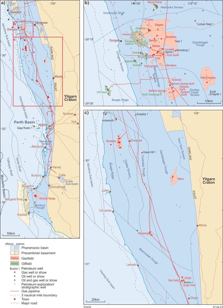
The Perth Basin extends west from the Yilgarn Craton to the edge of the continental shelf, southwest to the offshore Mentelle Basin and north-northwest along the edge of the Southern Carnarvon Basin. The basin covers about 205 000 km2, of which 50 000 km2 is onshore, and contains a Permian–Mesozoic succession up to 12 km thick. Offshore sub-basins contain a much thicker, mostly Mesozoic–Cenozoic, succession.
Two major onshore gas pipelines from Dongara and Dampier traverse the basin to near Bunbury and Pinjarra, respectively. The depleted Mondarra gasfield, connected to both pipelines near Dongara, provides temporary storage of up to 18 PJ. The field allows flexibility in supplying gas to the southwest of the State, with an injection capacity close to 70 TJ/d whereas it is possible to withdraw up to 150 TJ/d.

Geological setting
The Perth Basin formed as a north–south elongate rift along the southwestern margin of the continent. Onshore, the major structural features are the Darling Fault on the eastern edge of the Yilgarn Craton, with the main depocentres along the Dandaragan Trough and its southern equivalents. The contact with the offshore Mentelle Basin to the southwest is transitional. The basin contains mainly Permian and younger continental clastic rocks deposited in a rift system that culminated with the breakup of Gondwana in the earliest Cretaceous (Berriasian–Hauterivian). Two major tectonic phases incorporate Permian extension to the southwest and northwest transtension associated with breakup. Sinistral and dextral movements, respectively, are inferred along the Darling Fault during these phases. Many new faults developed during breakup and most major faults reactivated, with some producing associated wrench-induced anticlines.
Exploration history
The earliest exploration was shallow drilling on the margin of the basin near the State’s south coast during the early 1900s but without success. Exploration of the basin began in earnest in 1949, when the Bureau of Mineral Resources, Geology and Geophysics (BMR; now Geoscience Australia) commenced the first gravity survey in the northern onshore part of the basin. West Australian Petroleum Pty Ltd (WAPET) was the first private company to explore the basin with gravity and seismic surveys. Both the BMR and WAPET acquired the first seismic surveys in 1955 and drilled stratigraphic wells across the onshore northern Perth Basin in the late 1950s, leading WAPET to drill the basin’s first wildcat well, Eneabba 1, in 1961.
To date there are 338 onshore and 58 offshore (in Commonwealth Waters) wells in the basin, and over 450 seismic surveys acquired, of which 22 are 3D. The onshore wells include 167 new field wildcats, 34 stratigraphic wells, 134 development or extension wells and six wells for coal bed methane. Known hydrocarbon accumulations include 22 commercial oil and gas-condensate fields, of which 16 are now depleted or shut-in. Up to 2019, the basin yielded 20.4 Gl of gas (0.72 Tcf) and 5.4 Gl of oil (34 MMbbl). Gas production is likely to rise significantly given recent discoveries such as Waitsia, West and South Erregulla, and Lockyer Deep. Most wells lie in the northern onshore part of the basin, as do the commercial hydrocarbon accumulations (apart from Cliff Head) making this the second highest production region within the State’s jurisdiction.
Reservoirs for the productive oil and gas fields within the northern Perth Basin are mostly within the Permian or Lower–Middle Jurassic with minor production from the Lower–Middle Triassic. Of the fields still in production:
• Senecio and Waitsia have gas in the Lower Permian ‘Kingia’ and High Cliff Sandstones
• Cliff Head has oil in the Lower Permian Irwin River Coal Measures
• Beharra Springs, Jingemia, Redback and Tarantula reservoirs are in the Middle–Upper Permian Dongara Sandstone and Wagina Formation.
The Waitsia gasfield, discovered in 2014 by Senecio 3, is the largest onshore northern Perth Basin discovery to date with estimated gas reserves of 3.7 x 10⁹ m3 (1.3 Tcf) gas-in-place. Early depletion or shutting-in of some fields and lack of development in others has been caused by tight reservoirs in the basin. Gas in the basin is mainly dry, with over 94% methane and minimal condensate. Associated oil is typically light and highly paraffinic, with high wax contents, pour points and saturated hydrocarbons.
Prospectivity
The northern Perth Basin is the second highest petroleum-producing province under Western Australian jurisdiction after the State’s territorial waters of the Northern Carnarvon Basin. Petroleum-system analysis indicates widespread mature source rocks, abundant reservoirs and favourable timing of structures for hydrocarbon entrapment. Seal is a critical factor owing to the intense faulting and high sand-to-shale ratio of the post-Lower Triassic succession. The success rate for wells in the northern part of the basin since 2001 has increased due to the application of 3D seismic surveys, most of which were conducted north of the Woodada field. In addition, viable deeper plays, as shown by the Permian Waitsia gasfield, are also present. Major play types include Permian–Triassic and Jurassic anticlines, and Permian–Triassic tilted fault blocks and stratigraphic traps.
Four petroleum systems have been identified within the basin:
- Gondwanan 1 with a Permian source (e.g. Waitsia)
- Gondwanan 2 with a mostly Triassic source (e.g. Dongara, Cliff Head, Hovea and Mount Horner)
- Austral 1 with Jurassic sources (e.g. Walyering)
- Austral 2 with an Upper Jurassic – Lower Cretaceous source (e.g. the Gage Roads 1 oil show).
Whereas oil and gas production has decreased as fields deplete, deep gas resources have the potential to compensate for this decline, especially from fields such Waitsia and West Erregulla with plays encompassing the High Cliff and ‘Kingia’ Sandstones.
The Permian to Cretaceous stratigraphic and structural evolution of the southern Perth Basin is similar to that of the northern Perth Basin, but the area may have poor sealing potential as there are no thick marine intervals or thick regional shales below the Cretaceous. Nevertheless, several wells in the region had hydrocarbon shows of which the most significant were gas flows on test from the Permian Sue Coal Measures in the Whicher Range wells; however, attempts to stimulate this reservoir were unsuccessful.
The northern Perth Basin has attracted interest in geothermal energy based on seismic reflection data and petroleum wells indicating suitable temperatures and reservoir properties to support power generation from depths greater than 2500 m.
Given the number of fields in the north of the basin that are now depleted, or nearing depletion, there is a high likelihood that some will be repurposed to store flammable gas or geosequester CO2. At present, only Mondarra is used for temporary storage of natural gas but other fields may be required for such use if the capacity of the pipelines increases. Of the fields potentially available for H2 storage, smaller fields such as Xyris, Yardarino and Beharra Springs are highly rated, whereas Dongara may be too large for such a purpose.
The South West Hub — a 2011–18 government-funded research project located about 150 km south of Perth, — investigated the CO2 storage potential of Triassic sandstone over the ‘Harvey Ridge’. Although there is no structural trap or seal, and as yet no trial injections of CO2, modelling based on core and log analysis indicates the 1500 m-thick, brine-saturated sandstone could accommodate at least 800 000 tof CO2 per annum over 30 years. In addition, depleted fields may have potential for permanent CO2 sequestration, or temporary storage of gas or H2.
Download a table of Perth Basin shows and fields.
GSWA publications
-
 GSWA Record 2014/14
The tectonic framework of the Perth Basin: current understanding
GSWA Record 2014/14
The tectonic framework of the Perth Basin: current understanding
-
 GSWA Record 2011/14
Permian–Carboniferous geology of the northern Perth and Southern Carnarvon Basins
GSWA Record 2011/14
Permian–Carboniferous geology of the northern Perth and Southern Carnarvon Basins
-
 GSWA Report 46
Stratigraphy and structure of the onshore northern Perth Basin
GSWA Report 46
Stratigraphy and structure of the onshore northern Perth Basin
-
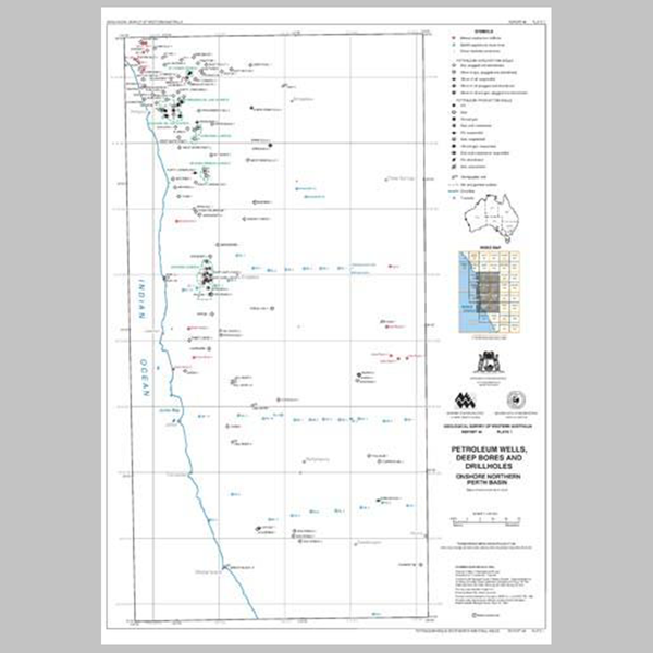 GSWA Report 46 plates
Onshore northern Perth Basin geology, seismic and well-correlation maps
GSWA Report 46 plates
Onshore northern Perth Basin geology, seismic and well-correlation maps
Further reading
Craig, A, Newman, S, Stephenson, P, Evans, C, Yancazos, S and Barber, S 2022, Hydrogen storage potential of depleted oil and gas fields in Western Australia: The APPEA Journal, v. 62, no. 1, p. 185–195, doi:10.1071/AJ21146.
Meckel, T, Wright, M, Blair, G, Ballesteros, M, Farley, A and Cortis, A 2022, Conceptual model of the Lower Permian Kingia Sandstone (northern Perth Basin, Western Australia) as an alternative energy resource: The APPEA Journal, v. 62, no. 2, S449–S455, doi:10.1071/AJ21069.
Norvick, MS 2004, Tectonic and stratigraphic history of the Perth Basin: Geoscience Australia, Record 2004/16, 30p.
Olierook, HKH, Timms, NE, Wellmann, JF, Corbel, S and Wilkes, PG 2015, 3D structural and stratigraphic model of the Perth Basin, Western Australia: Implications for sub-basin evolution: Australian Journal of Earth Sciences, v. 62, no. 4, p. 447–467, doi:10.1080/08120099.2015.1054882.
Tupper, N, Matthews, E, Cooper, G, Furniss, A, Hicks, T and Hunt, S 2016, The Waitsia Field, onshore North Perth Basin, Western Australia.: The APPEA Journal, v. 56, p. 29–46, doi:10.1071/AJ15003.
Contact
For further information contact:
basinenergy.geoscience@dmirs.wa.gov.au