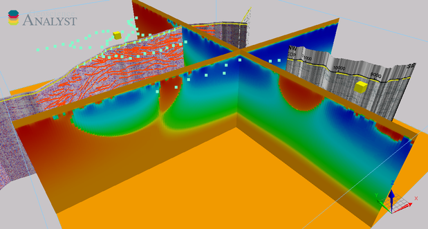
This model accompanies Minerals Research Institute of Western Australia (MRIWA) Report No. 476, An integrated multi-scale study of crustal structure and prospectivity of the eastern Yilgarn Craton and adjacent Albany–Fraser Orogen, and places all the components of the project in the correct 3D space. Like many governments in resource-rich countries, the Western Australian government is encouraging exploration in what are perceived to be ‘underexplored’ terrains within its jurisdiction. The next phase of the Exploration Incentive Scheme (EIS) will concentrate on the margins of cratonic regions of Western Australia and surrounding orogens. The eastern Yilgarn Craton (Yamarna Terrane / Albany–Fraser Orogen) is one such area, and is significant for the presence of the recent Gruyere gold discovery and the world-class Tropicana gold deposit.
The project objectives for Project M476 were to:
- determine crustal structure in the region containing the Gruyere gold deposit with an emphasis on identifying key components of the associated mineral system (deep-penetrating fault structures) using a data-integrated interpretation approach
- use all relevant geological, petrophysical and geophysical data to map in 3D the Yilgarn Craton and adjacent Albany–Fraser Orogen in the region between the Gruyere and Tropicana deposits
- map the Yamarna Shear Zone and the western margin of the Yamarna Terrane to determine if it extends southeastwards towards the Tropicana gold deposit and, by implication, is a component of the Tropicana mineral system
- compare the magnetotelluric (MT)-derived conductivity model and the reprocessed deep seismic data to assess their relative ‘ability’ to image steep- and shallow-dipping structures and determine their depth extent
- image the Yamarna belt mineral system using MT, magnetic, gravity and seismic data
- determine the efficacy of datasets at imaging the crustal architecture in the study area.
For further information contact:
3D.geoscience@dmirs.wa.gov.au
