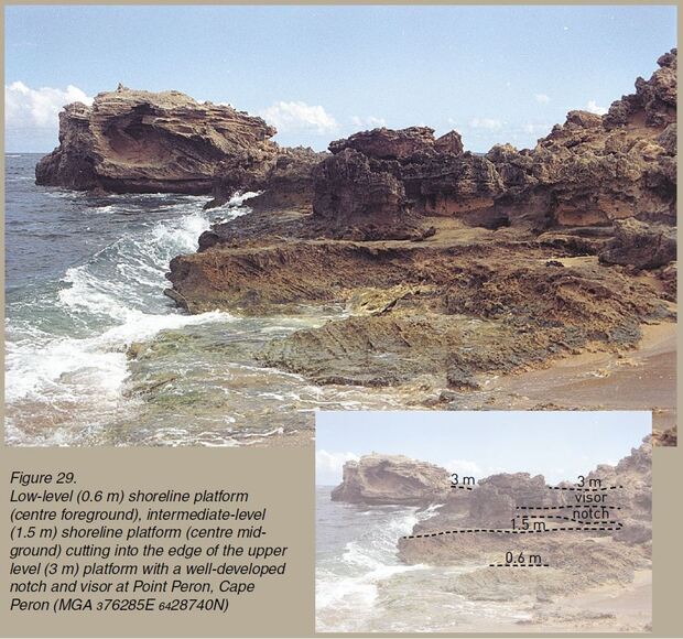
Stretching from the ocean to the eastern hills, the Perth region has coastal landscapes, river-valley landscapes and forested hilly landscapes that reflect the diverse geology beneath. This field guide covers some of the classic geological localities near Perth. For instance, Cape Peron has preserved evidence for sea-level changes that have featured in scientific discussions for more than 50 years. The guide describes its landscape and rocks, and gives explanations about how they formed. Close-up photos and diagrams enable readers to recognise and interpret the localities.
_rdax_1240x450s.JPG)
This book provides an insight into the range of natural features that are present in and around Perth, explains the origin and evolution of various landscapes, and describes the underlying geology in relation to the landscape.
From the stability of the Darling Range to the dynamic coastal environments, the landscapes of the Perth region and their underlying geology have influenced the development of Perth.
Among the features covered in the book are:
- the landforms of the coastal areas that record fluctuating sea level as a result of the glaciations of Pleistocene times
- the exposed riverbanks and subtle landforms of the Swan Valley that reveal the history of past migrating river systems
- sedimentary rocks of marine origin at the foot of the Darling Range that are evidence for an ancient shoreline, when the ocean covered all of what is now the Swan Coastal Plain
- quarries on the Darling Plateau that reveal the complex history of the ancient Yilgarn Craton, where belts of metamorphic rocks were intruded by large volumes of granite, and then eroded and deeply and intensely weathered over millions of years
Who should read the book?
This book is a concise, informative and simple guide aimed at providing a better understanding and appreciation of the geology and range of natural features of the Perth region.
It is aimed at those in secondary and tertiary education who require resource materials for teaching, and those with a basic understanding of geological principles, but it is also readily accessible to the layperson. If a geological term is not explained as part of the discussion, then it is written in bold and defined or described in more detail in the glossary.
What is in the book?
This field guide covers some of the classic geological localities around Perth including:
- beaches and ocean
- the hills east of Perth
- quarry sites
- river valleys in a National Park
The book includes close-up photos and annotated images to help readers understand the places they visit. It is also a handy addition for the glove box of your car.
Those interested in finding out more about the geology of Perth, might also like to read A Field Guide to Perth and Surrounds, written by John Bunting and Earth Science WA. This field guide features an overview of the geology of Perth, and is designed to make your geological excursions easy and enjoyable. It covers six geologically significant locations with detailed descriptions at each locality and a comprehensive glossary.
How to access the book
To buy a hardcopy of Geology and landforms of the Perth region by JR Gozzard, please email bookshop@dmirs.wa.gov.au. You can also download a free PDF from the link below.
Geology and landforms of the Perth region