This survey aims for a better understanding of the subsurface geology of the Canning Coastal region, how the Australian continent was assembled as a result of plate tectonic process over billions of years, and the probable substrates to the basin. Such knowledge assists in identifying areas of petroleum, mineral, groundwater and geosequestration potential in the largest basin in Western Australia.
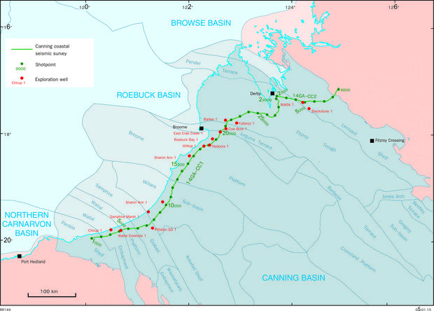
The Canning Coastal seismic and gravity survey data were acquired by Terrex Seismic in May–June 2014 for the Department of Mines and Petroleum (DMP) and Geoscience Australia (GA). The 700 km survey stretched the full width of the Canning Basin from the Pilbara Craton to the Kimberley Craton, along the Great Northern Highway, and the Derby and Gibb River Roads (see location map). Data were recorded down to 20 seconds. DownUnder GeoSolutions processed the seismic data between September 2014 and February 2015.
Acquisition of the seismic and gravity survey was funded through the Western Australian Government’s Exploration Incentive Scheme (EIS). Processing of the seismic data was funded by the Australian Government’s Department of Industry.
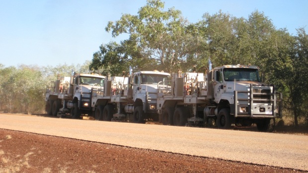
Nearly two terabytes of data were recorded by a convoy of about 20 vehicles with a crew of about 40 people. Three specialized Hemi-50 Vibroseis trucks stopped every 40 m and deployed large metal pads to create vibrations barely perceptible to people 100 m away, but capable of penetrating through the crust and upper mantle to depths of up to 50 km. Reflected seismic energy from each stop was recorded over 600 live channels spread over 12 km.
Gravity data were also collected along the route, with a minimum spacing of 360 m and a maximum spacing of 800 m (Line 14GA-CC1) or 440 m (Line 14GA-CC2).
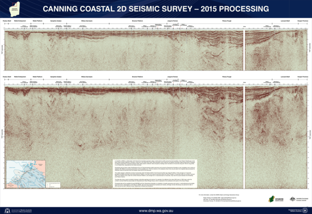
The GSWA 2015 Open Day poster and image below show the 8-second and 20-second versions of the pre-stack time migrated SEGY data.
Access data
Pre-stack time migrated, pre-stack depth migrated, and post-stack time migrated SEGY seismic data is available for download via the Western Australian Petroleum Information Management System (WAPIMS). Alternatively, a portable hard drive containing all data (including gathers) can be ordered by emailing requests to petdata@dmirs.wa.gov.au (Perth) or ausgeodata@ga.gov.au (Canberra).
The raw gravity dataset is available for download from the Airborne Geophysics Index (MAGIX) layers using the Geological Survey of Western Australia’s interactive map-viewing application, GeoVIEW.WA, or from WAPIMS.
To order a hard drive containing the raw seismic field data, send an email request to Geoscience Australia.
Contact
For more information contact:
geological.survey@dmirs.wa.gov.au
basinenergy.geoscience@dmirs.wa.gov.au