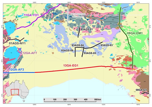
The Eucla–Gawler deep crustal seismic reflection line and MT surveys were conducted across Western Australia’s Nullarbor region during 2013 to February 2014. This 870-kilometre transect along the Trans-Australian Railway fills a gap in seismic coverage, completing a string of deep-crustal seismic transects that stretch from west to east across the Australian continent. This coverage will enable researchers and explorers to assess deep-crustal structures using a nationally consistent dataset, and is an important asset to geologists trying to reconstruct the tectonic evolution of Australia.
The Eucla–Gawler surveys extend from Haig in southeastern Western Australia to Tarcoola in South Australia. They were designed to:
- cross the greenfields basement provinces and their margins under the Eucla and Bight Basins
- image regional-scale basement magnetic and gravity features such as the Mundrabilla Shear Zone and the Coompana magnetic feature
- examine crustal links between the Yilgarn Craton and the highly prospective Gawler Craton in South Australia


The Eucla–Gawler deep seismic profile and MT surveys are a national collaboration between Geoscience Australia (GA), the Geological Survey of Western Australia (GSWA), the Geological Survey of South Australia and AuScope Earth Imaging (part of the National Collaborative Research Infrastructure Strategy). GA is contributing financially to the project through the new minerals pre-competitive data funding it received in November 2012, with funding in South Australia through the Plan for Accelerating Exploration PACE initiative and in Western Australia through the department’s Exploration Incentive Scheme (EIS).
The Eucla–Gawler survey provides a link to previous surveys in Western Australia’s Yilgarn Craton and adjacent Albany–Fraser Orogen, the Gawler and Curnamona Provinces in South Australia, and the Musgrave Province and Amadeus Basin in the Northern Territory. The survey has extended a 300-kilometre seismic line acquired in 2012 along the path of the Trans-Australian Railway from east of Kalgoorlie in Western Australia. It also links to another seismic line acquired in 2009, which extends 634 kilometres north from Tarcoola in South Australia to near Kulgera in the Northern Territory.
The Eucla–Gawler region (Nullarbor Plain) is a major geological frontier, with very little information available on the subsurface geology. The region lies between two of the most prospective geological regions in the world, the Yilgarn Craton to the west and the Gawler Craton to the east. However, the extensive sedimentary cover associated with the Eucla Basin has led to the bedrock underlying this region being very poorly represented and understood.
Some of the geological unknowns in this region include the:
- deep crustal structure of the basement geology under the Eucla Basin and the likely geological processes that drove Mesoproterozoic tectonic assembly between the West Australian Craton and the South Australian Craton
- deep crustal structure of the eastern margin of the Albany–Fraser Orogen and western margin of the Gawler Craton
- nature of the Mundrabilla Shear Zone as a crustal-scale structure
- nature and character of the Moho
- margins of the Coompana magnetic feature and associated magnetic lineaments
- structural relationships between tectonic units mapped at the surface (such as neotectonic features)
- structural elements of the Eucla Basin and underlying basins, which may host hydrocarbons.
Final, uninterpreted migrated tif images and supporting data for seismic line 13GA-EG1 are available for download here:
- 13GA-EG1_basin_images_150dpi
- 13GA-EG1_basin_images_300dpi
- 13GA-EG1_images_150dpi
- 13GA-EG1_images_300dpi
- Supporting_Data
These data and other formats are also available from Geoscience Australia.
Interpreted sections of the Madura and Coompana Provinces
Exposing the Nullarbor session at the AESC in Adelaide, June 2016
Interpretations of seismic line 13GA-EG1 and related data were presented at the Exposing the Nullarbor session at the AESC in Adelaide, June 2016. Posters of the interpretations and the presentations are available for download:
| Presentation | Presenter | Organisation |
|---|---|---|
|
Acquisition & Processing Of The 2013 Euclagawler Seismic Survey (L203) Line 13ga-Eg1 |
Josef Holzschuh | GA |
| Betina Bendall1, Brent Jensen-Schmidt, Simon Holford, Rian Dutch, and Mark Pawley | DSD | |
| T.W. Wise, M.P. Doublier, R.A. Dutch, D. Clark, M.J. Pawley, G.L. Fraser, B.L.N. Kennett, A.J. Reid, C.V. Spaggiari, A.J. Calvert, S. van der Wielen, H. Dulfer, B.R. Bendall, S. Thiel, and J. Holzschuh | DSD | |
| Geoff Fraser and Narelle Neumann | GA | |
| Rian Dutch, Catherine Spaggiari, Michael Doublier, Mark Pawley, Tom Wise, Brian Kennett, Klaus Gessner, Stephan Thiel, Dan Clark, and Josef Holzschuh | DSD | |
| Catherine Spaggiari, Rian Dutch, Michael Doublier, Klaus Gessener, Stephan Thiel, Mark Pawley, Brian Kennett, Hugh Smithies, Tom Wise, Dan Clark, Josef Holzschuh | GSWA | |
|
Investigation of the Coompana negative magnetic anomaly in southwestern South Australia |
Clive Foss, Gary Reed, Philip Heath, Rian Dutch and Tom Wise | DSD |
|
Lithospheric structure in the vicinity of the Eucla-Gawler reflection profile |
B.L.N. Kennett, R. Chopping | ANU |
|
Linking Western and South Australia –insights from magnetotelluric profiling |
S. Thiel1, M. Dentith, T. Wise1, J. Duan, J. Spratt, C. Spaggiari, M. Pawley, R. Dutch1, K. Gessner, H. Smithies, M. Doublier | DSD |
| Gessner, Klaus, Murdie, Ruth E, Brisbout, Lucy, Spaggiari, Catherine V, Brett, John, Dutch, Rian A, Thiel, Stephan, Wise, Tom, Pawley, Mark J | GSWA, GSSA | |
| Poster Plate 1 Western Gawler Seismic | ||
| Poster Plate 2 Coompana Seismic | ||
| Poster Plate 3 Madura Seismic |
Contact
For more information contact:
geological.survey@dmirs.wa.gov.au
