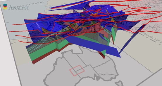
This 3D model was built by the Centre for Exploration Targeting (CET) at The University of Western Australia in conjunction with the Geological Survey of Western Australia (GSWA) and was funded by the Exploration Incentive Scheme. It uses gravity and magnetic data in conjunction with magnetotelluric (MT) and seismic reflection data over the west Musgrave Province to define the geometry of the structures and subsurface geology of the province by means of geophysical inversion. This 3D model is the product of work described in detail in GSWA Report 114.
Detailed mapping of the west Musgrave Province in 2003-2014 has greatly improved the knowledge of geology and geological history of the area. Important discoveries such as the Nebo–Babel Ni–Cu–PGE deposit and other known mineralised occurrences indicate the potential for further economic discoveries in the region. This model was built to investigate subsurface geology and the deep-penetrating structures that may be considered conduits for hydrothermal fluids and magmas. A companion study, GSWA Report 117, looked at the detailed interpretation of magnetic and gravity maps and assessed the area for its mineral prospectivity. The current work extends the map interpretation into 3D, and tests and constrains the model using all available data.
The model shows that, although earlier and later events are locally influential, the present-day crustal structure is largely a product of the Giles Event and Petermann Orogeny. The Giles Event saw the addition of layered mafic intrusions to the crust emplaced along an east-southeast rift axis bounded by faults, which allowed inflation of the crust. Subsequently, massive gabbroic intrusions were emplaced along a north-northwesterly trending, west-plunging axis. The late stages of the Giles Event saw the deposition of the volcano-sedimentary packages of the Bentley Supergroup on a characteristic east-southeast to west-northwest trend reflecting the broad structure of the rift, which defines the structure of the Mamutjarra Zone. The Petermann Orogeny is characterised by differing styles of deformation in each of the zones of the province. In the Tjuni Purlka zone, major crustal-scale transpressional shear zones accommodate significant offsets, and in the Walpa Pulka zone, lower-crustal material is thrust over the Mulga Park zone with associated crustal thickening. The Mulga Park zone is thickened by low-angle thrust faulting.
For further information contact:
3D.geoscience@dmirs.wa.gov.au
