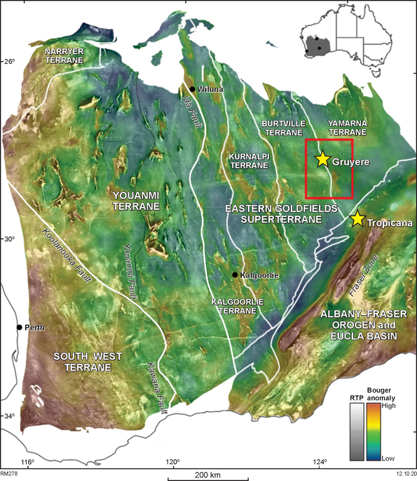
The Yamarna MT survey was designed to study the conductivity of the western margin of the Yamarna Terrane in the far Eastern Goldfields, where significant gold deposits have been discovered.
The Centre for Exploration Targeting at The University of Western Australia commissioned an MT survey across the southern Yamarna region as part of MRIWA Project M476 ‘An Integrated Multiscale Study of Crustal Structure and Prospectivity in the eastern Yilgarn Craton and Adjacent Albany–Fraser Orogen’. This project was designed to study the nature of the boundary between the Yilgarn Craton and the adjacent Albany–Fraser Orogen. Specific objectives included the investigation of the western margin of the Yamarna Terrane, the Gruyere orogenic gold mineral system and assessing whether any structures from this region could be mapped southwards to see if there is any relationship between the Gruyere system and the Tropicana deposit to the south.
The Gruyere deposit is located at a flexure point in the Dorothy Hills Shear Zone that runs through the Dorothy Hills greenstone belt. Gold mineralisation is hosted in the ‘Gruyere Tonalite’, a medium-grained, porphyritic quartz monzonite to tonalite that intruded the greenstone belt parallel to the shear zone.
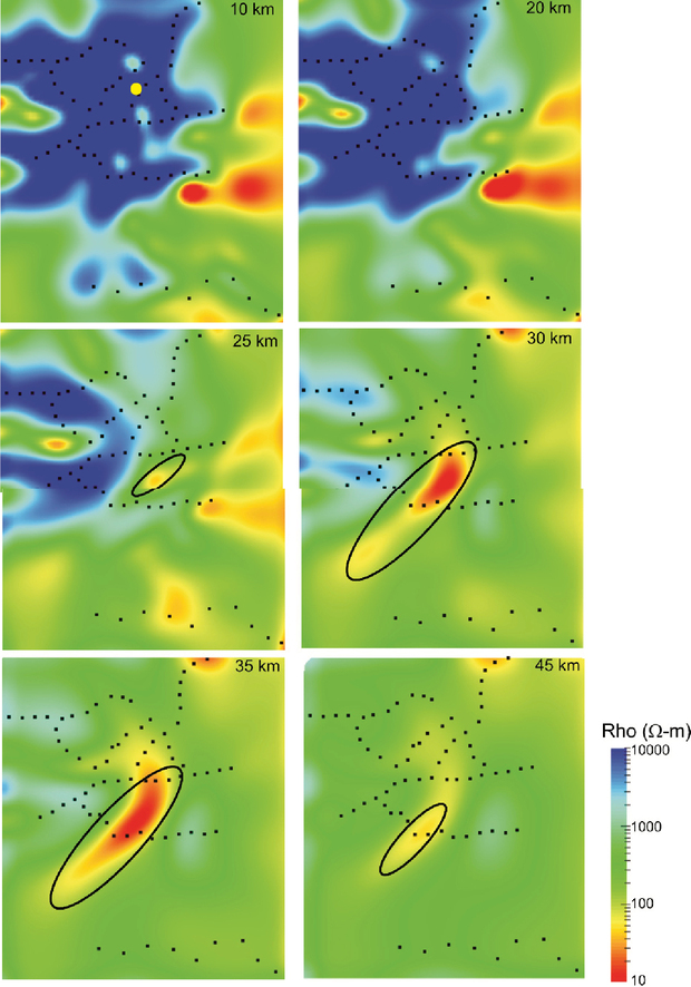
Seventy-six broadband MT sites were acquired by Moombariga Geoscience at 5 to 10 km spacing in order to image the 3D geometry and resistivity structure of the region. Transient electromagnetic (TEM) data were also recorded at the MT sites to try to account for static shifts of the apparent resistivity curves in the MT data.
Results showed southwards-plunging conductive shear zones along the Yamarna Shear Zone (the boundary between the Burtville Terrane and Yamarna Terrane) and Dorothy Hills Shear Zone, which may represent the fluid pathway for mineralisation associated with the Gruyere deposit. An anomalously conductive northeast–southwest zone imaged within the lower crust may be related to Albany–Fraser orogenic processes.
More information about the survey and the results are presented in MRIWA webpage for Project 476, An Integrated Multiscale Study of Crustal Structure and Prospectivity in the eastern Yilgarn Craton and Adjacent Albany-Fraser Orogen.
Contact
For further information contact:
geological.survey@dmirs.wa.gov.au