Area Summary
Petroleum Acreage Release 1 of 2020 – Area L20-2
Released: Friday, 17 July 2020
Closed: Monday, 19 October 2020
Areas available: Petroleum and Geothermal Energy Resources Act 1967 (PGERA)
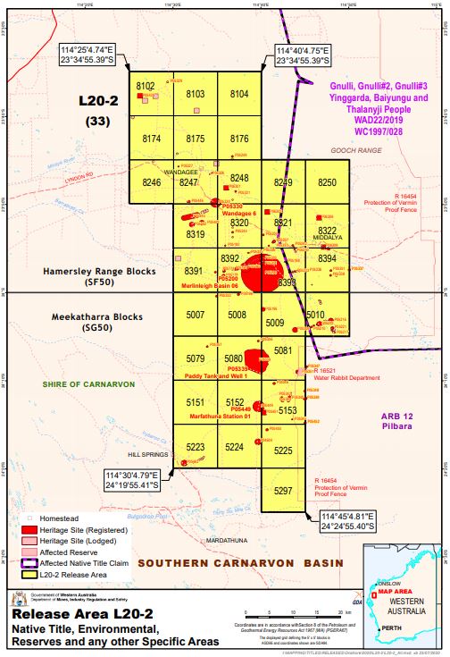
Area: L20-2
Graticular blocks:
1:1,000,000 Hamersley Range Blocks Map Sheet (SF50)
| Block No | Block No | Block No | Block No | Block No |
| 8102 | 8103 | 8104 | 8174 | 8175 |
| 8176 | 8246 | 8247 | 8248 | 8249 |
| 8250 | 8319 | 8320 | 8321 | 8322 |
| 8391 | 8392 | 8393 | 8394 |
1:1,000,000 Meekatharra Blocks Map Sheet (SG50)
| Block No | Block No | Block No | Block No | Block No |
| 5007 | 5008 | 5009 | 5010 | 5079 |
| 5080 | 5081 | 5151 | 5152 | 5153 |
| 5223 | 5224 | 5225 | 5297 |
Contains thirty three (33) blocks to the extent only that the area is within the State as defined in section 26 of the PGERA.
Moratorium on Hydraulic Fracturing
Please be advised, the State Government’s decision to indefinitely extend the moratorium means that hydraulic fracturing cannot be undertaken under any new petroleum exploration permit granted in relation to Discrete Areas L20-1, L20-2, L20-3 and L20-4 by way of this acreage release process. Furthermore, any subsequent petroleum title deriving from this acreage release process will be prohibited from utilising hydraulic fracturing for exploration or production. For clarity this will include any production licences or retention leases arising out a permit granted from Release 1 of 2020. The continuation of the moratorium has been given effect by way of amendments to the Petroleum and Geothermal Energy Resources (Hydraulic Fracturing) Regulations 2017. These amendments took effect in September 2019.
Available data and maps
Contact
For any general enquiries please contact the Resource Tenure team
Email: petroleum.titles@dmirs.wa.gov.au
For data enquiries please contact the Statutory and Resource Information team
Email: petdata@dmirs.wa.gov.au

