Geologists in the Geological Survey of Western Australia (GSWA) study the rocks and landscape that make up the State. By recording the distribution and relationships of different rocks, and taking samples for laboratory study, they can find out how and when these rocks formed. The knowledge gained is produced as geological maps, datasets and reports, which help the community, industry and government to plan for the future.
Download Mapping Western Australia poster
It's a big State
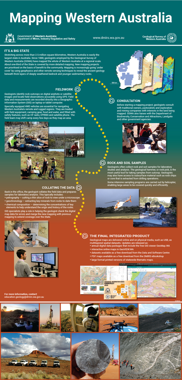
Stretching across more than 2.5 million square kilometres, Western Australia is easily the largest state in Australia. Geological mapping started in the middle of the 19th century, with geological observations made during expeditions in search of mineral deposits, water and pastoral land. GSWA was established in 1888, when the first full-time Government Geologist was appointed. Systematic mapping started in the 1950s, and by 1980 the whole State had been mapped at 1:250 000 scale. More detailed mapping at a 1:100 000 scale followed and continues today, although the methods have changed significantly. New mapping projects at GSWA are prioritised on the basis of potential for maximum benefit to the community.
Consultation
Before starting a mapping project, geologists consult with Aboriginal, pastoral and mining stakeholders to ensure land access and respect land ownership. The geologists also liaise with the Department of Biodiversity, Conservation and Attractions, and other government agencies, to identify environmental issues.
Fieldwork in the bush
In the late 19th to early 20th century, camels and horses were used during geological expeditions. These were gradually replaced during the 1920s in favour of motor vehicles, with ships and rail used to cover longer distances. Occasional use of aeroplanes began in the 1930s.
Today, geologists use four-wheel-drive vehicles to get to rock outcrops. They carry camping and safety equipment, as well as food and water. They may shift basecamp every few days, or camp at a different place each night, as they map an area.
Helicopters are sometimes used to access remote outcrops. They are more effective for the collection of samples over wide areas during regional geochemical surveys.
On the ground, geologists use digital airphotos and satellite images together with GPS tracking to locate outcrops. Measurements are made with a compass, and detailed field observations are recorded directly into a geographic information system (GIS) database using a tablet computer designed for the rugged conditions of fieldwork.
Rock and soil samples
Geologists collect rock and soil samples for further studies. These typically include:
- petrography — cutting a thin slice of rock to view under a microscope, which helps identify the different minerals that make up the rock
- geochronology — extracting key minerals from rocks to date them
- chemical analysis — determining the concentrations of many elements to help understand the origin and history of the rocks.
Compiling the data
Map compilation is now fully digital, replacing the hand drawn and coloured productions of the past. Geological data are assembled using GIS software that allows for better spatial accuracy. The geological information is superimposed on a topographical basemap and the geological map takes shape as the geologist joins the dots between known rock outcrops where field data were collected. Knowledge from the field is combined with geophysical and satellite data to create a bigger picture, and deeper understanding, of the geology. A map legend is an essential part of the geological map, showing the age, rock types, sequence and structural relationships of rock units in a given area.
Samples collected during fieldwork are analysed to determine their composition and age, and these results help the geologist to interpret field data.
GIS specialists play a role in helping the geologist check the digital map data for topological errors and merge new and previous mapping to extend coverage over the State.
The integrated product
GSWA produced traditional geological maps drawn to the boundaries of 1:250 000- or 1:100 000-scale grids up to about 2016. Since the mid-2010s, printed maps have been phased out and new mapping is released as part of comprehensive geoscience data packages, as GIS files to download from the Data and Software Centre and directly online via GSWA’s GeoVIEW.WA map platform. This video shows how to use GeoVIEW.WA. Digital data layers are underpinned by database extracts that allow the map view to be interrogated by the user. For example, querying a rock type shown in the digital map returns information about age, chemistry, petrology, and relationships to other rocks.
GSWA also provides a free GIS tool, GeoMap.WA, to view, query and manipulate geoscience information. Users can take the data into the field on a laptop computer or tablet — or explore the geology from the comfort of home — rather than relying on a simple paper map spread over the vehicle bonnet.
Rock and soil samples
Geologists collect rock and soil samples for further studies. These typically include:
- petrography — cutting a thin slice of the rock to view under a microscope, which helps identify the different minerals that make up a rock
- geochronology — extracting key minerals from rocks in order to date them
- chemical analysis — determining the concentrations of many elements and understanding rock origins
Back at the office
The geological map takes shape as the geologist combines the information gathered during fieldwork and the subsequent analyses onto a map base. Today, geophysical imagery, particularly detailed aeromagnetic imagery, is an integral part of the interpretive process.
Computerised maps
In the past, maps were hand drawn and hand coloured, but computers now make the job more accurate. Geological data is assembled using Geographic Information System (GIS) software that allows a better spatial accuracy. Each map typically comprises a base with topographic information with a superimposed coloured geological map. A map legend is an essential part of the geological map, and illustrates the age, lithology, stratigraphy and structural relationships of rock units in a given area.
The final map
Geological maps are plotted by computers rather than offset printed. As well as rock types and outcrops, the maps show creeks, roads, tracks, bores, mineral deposits and other landmarks. They may provide the most accurate topographic information available, as ground-truthing is part of the mapping process. Physical maps are now just one layer in a multi-layered package of intelligent digital spatial data. GSWA provides a free GIS tool, GeoMap.WA, to view, interrogate and manipulate this data. Users can take the data into the field via a laptop computer, rather than a simple paper map spread over the vehicle bonnet.
Western Australian geologists are working on projects across the whole State, from the oldest rocks to the youngest landforms.
Contact
For more information contact:
geological.survey@dmirs.wa.gov.au