The Geological Survey of Western Australia (GSWA) reprioritized its 2020–21 work program due to the impact of travel and operational restrictions imposed by the COVID-19 pandemic. By using its extensive, geoscience datasets and outstanding rock and paleontology collections, GSWA’s Accelerated Geoscience Program (AGP) aims to aid economic recovery and stimulate the exploration industry. GSWA has delivered new interpretive datasets across all areas of geoscience in key regions of the State, accelerating understanding of the regions’ geology and mineral prospectivity.
AGP main projects
Dedicated geoscientists from across GSWA have concentrated their efforts on four main projects:
- Publication of existing data into GIS layers
- Data integration and analyses — the Yilgarn Craton
- Statewide critical minerals prospectivity study
- Energy systems including petroleum, geothermal, and carbon capture and storage.
Find the entire list of AGP products on the DMIRS eBookshop in a compilation called Record 2021/4 Accelerated Geoscience Program extended abstracts 2021. Some highlights are presented below.
To date, the AGP has delivered close to a hundred new interpreted datasets across the four projects, consisting of about 1080 interpreted data layers that comprise original work by GSWA and repurposed or reprocessed data originating from other organizations. Many of the layers have been published online and are available through the Data and Software Centre, GeoVIEW.WA, the Petroleum and Geothermal Information Management System (WAPIMS) and the Mineral Systems Atlas. However, most of the data are available within three standalone Geological Exploration Packages:
These standalone packages facilitate use for all levels of technical competency and software, from prospectors to Tier 1 companies. As these datasets formed part of the State’s economic recovery from COVID-19, the three Geological Exploration Packages will be available at no cost from the first floor front counter in Mineral House and at other events attended by GSWA.
Publication of existing data into GIS layers
This project has delivered previously non-digital datasets as new spatial datasets. The idea was to provide geological insights into the composition and fertility of the State's bedrock geology at a regional-scale, particularly in areas where the rocks are buried by extensive cover. These datasets can be used to investigate the potential for operating minerals systems at the craton- to Province-scale and can be used to address the relationship between the crustal architecture, geology, geochemical and isotopic signatures with known sites of mineralization.
This project also focused on improving GSWAs databases, in particular the Western Australian Mineral Exploration (WAMEX) company geochemistry database, as well as providing accessibility to the online WAMEX reports. The WAMEX drillholes database was harmonized and is now publically accessible online, and over 260 000 WAMEX reports have been digitally captured which are now accessible and searchable through an elastic search.
The project has delivered 13 new datasets (160 layers) at the State scale and provide a significantly improved understanding of the prospectivity of Western Australia. These new results also feed into other AGP projects.
Data integration and analyses — the Yilgarn Craton
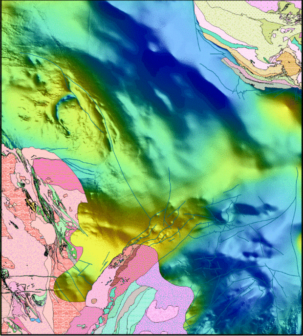
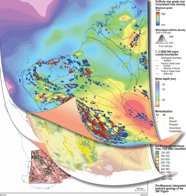
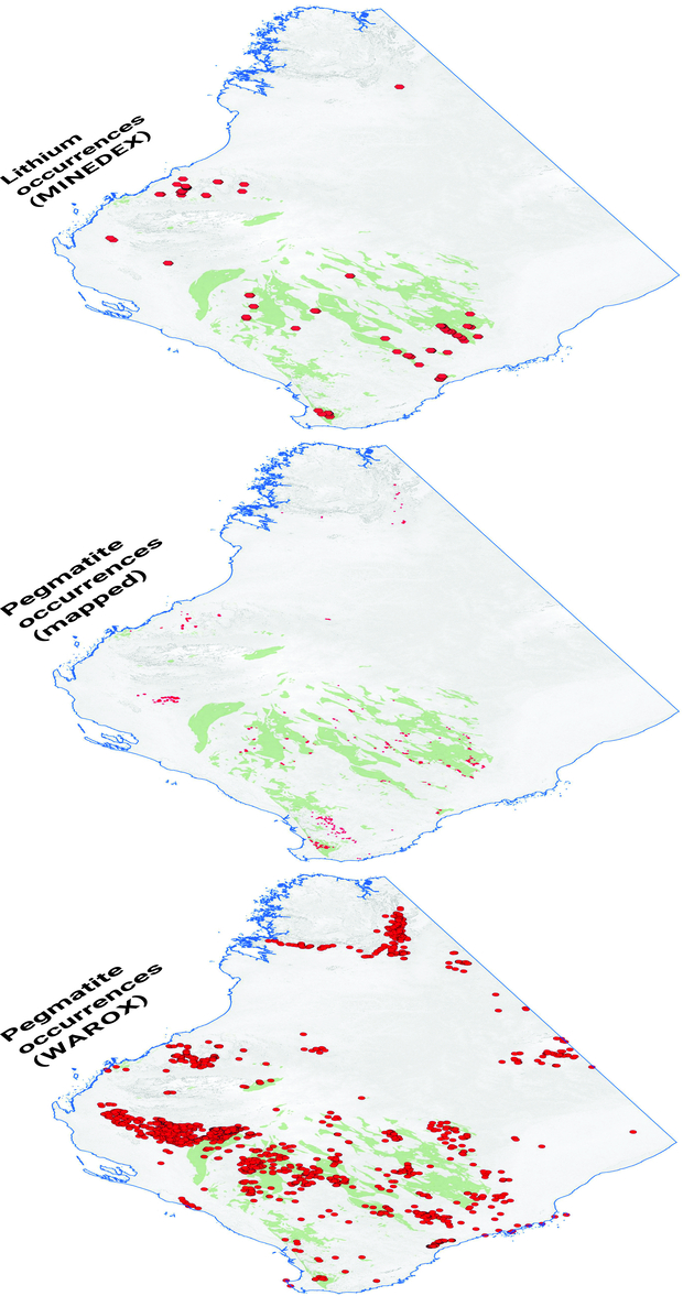
The Yilgarn Craton is one of Western Australia’s most prospective regions and contains significant deposits of gold, nickel, lithium, copper–zinc, iron ore, tantalum, aluminium and uranium. Recent high-grade gold and nickel discoveries in the craton’s far eastern (Gruyere, Tropicana, Neale) and southwestern margins (Julimar), have shown that these two poorly exposed and geologically not well-understood regions are likely to be as prospective as the craton’s interior (i.e. Eastern Goldfields). Despite both regions being covered by a thick blanket of regolith, GSWA holds a vast amount of geoscientific data relating to the bedrock and regolith geology with the potential for uncovering significant, new mineral deposits.
The minerals industry is increasingly aware that the new era of Tier 1 deposits is likely to be under deep cover. Working to the UNCOVER plan, the AGP has delivered 55 new integrated geoscience datasets (500 layers) for the southwestern and far eastern Yilgarn Craton margins. The program has also incorporated the results of ongoing work in the Eastern Goldfields, and performed new analyses on archived samples.
Statewide critical minerals prospectivity study
Both the State and Federal Governments have outlined a list of minerals that are deemed critical for emerging high-tech applications and are considered essential for economic and industrial development over the next decade. Western Australia is well placed to capitalize on increasing demand for critical minerals as we transition globally to low-carbon technologies. Knowledge of the geological settings where these deposits are likely to be located not only reveals emerging exploration plays but allows the government the foresight to manage land for strategic industrial purposes such as downstream processing.
The aim of this project was to catalogue the known critical mineral resources of the State to better understand the mineral systems in which they occur and the associated alteration systems. The program has delivered 20 new datasets consisting of 251 new layers that will help to define new exploration targets and to stimulate and increase investment in the critical minerals sector by releasing new parts of the State to exploration.
Energy systems including petroleum, geothermal, and carbon capture and storage
This project has created 12 new datasets consisting of 129 data layers that critically define elements of petroleum and geothermal systems to enhance regional understanding of the prospectivity of the State’s potential energy resources, including low-carbon technology.
The petroleum industry has been one of the most affected by COVID-19, having a simultaneous supply and demand shock caused by an oil price war that coincided with the start of the pandemic. The goals of this project were to produce a graphic summary of the State’s well data, in addition to other GIS layers, that will directly benefit petroleum industry exploration.
Find the entire list of AGP products on the DMIRS eBookshop in a compilation called Record 2021/4 Accelerated Geoscience Program extended abstracts 2021.
Contact
For more information contact:
michele.spencer@dmirs.wa.gov.au