Transforming to a new Geocentric Datum 2020 - a shift to greater accuracy
The Department of Mines, Industry Regulation and Safety (DMIRS) is preparing for the introduction of the Geocentric Datum of Australia 2020 (GDA2020) to adjust for tectonic plate movements.
Australia is moving north-east by about seven centimetres each year, colliding with the Pacific Plate, which is moving west about 11cm each year.
This movement means the location of geospatial coordinates changes over time and adjustments to the Australian datum are required to maintain ground accuracy.
Rather than making continuous changes, the adjustments are made at certain agreed times. Work is currently underway nationally to introduce GDA2020.
The Western Australian mining and petroleum title registers comprise both a textual description and a spatial representation for all tenements throughout Western Australia.
The current DMIRS description for mineral exploration licences is a geographical coordinate set comprising latitude and longitude intersections using the Geocentric Datum of Australia 1994 (GDA94)
Previously, a change of about 200 metres occurred in the year 2000 when Australia shifted from the Australian Geodetic Datum 1984 (AGD84) to GDA94.
A new shift of about two metres was introduced by the National Measurement Institute in 2017, with the new datum based on position estimates in 2020.
This new datum is known as GDA2020 and the difference between the current GDA94 and new datum is much smaller than last time - only about 1.8 metres.
As location precision and accuracy are becoming ever more important in the future, DMIRS is working with stakeholders to ensure the datum shift is progressed effectively.
The department’s top priorities are managing the update smoothly, maintaining certainty of tenure for all tenement holders, and ensuring our systems and data comply with the new national standard.
The department is well underway in its project to transition to GDA2020. The majority of spatial datasets available from the DMIRS Data and Software Centre (DASC) have been available in GDA2020 as of 1 July 2020.
Legislative change is required before tenements can be administered using GDA2020, and these amendments are currently being progressed. As such, DMIRS internal spatial systems remain GDA94-based for now and facilities to accept data in GDA2020 are not yet available.
The Mining Amendment Act (No. 2) 2022 came into effect on the 2 November 2022. Work is currently under way on regulations to support the full adoption of GDA2020.
To read more about datum modernisation, visit the Intergovernmental Committee on Surveying and Mapping (ICSM) website.
For more information about DMIRS’s involvement, please email the DMIRS GDA2020 project team at GDA2020@dmirs.wa.gov.au.
If you are having trouble viewing this video, please use the link Small Island Studio.
Video courtesy of ICSM and Small Island Studio
This link from Landgate contains attributes of Standard Survey Marks (SSM) and Bench Marks (BM) that have been coordinated in the GDA2020 datum.
Map showing location of Mineral House in East Perth (AGD84, GDA94, GDA2020)
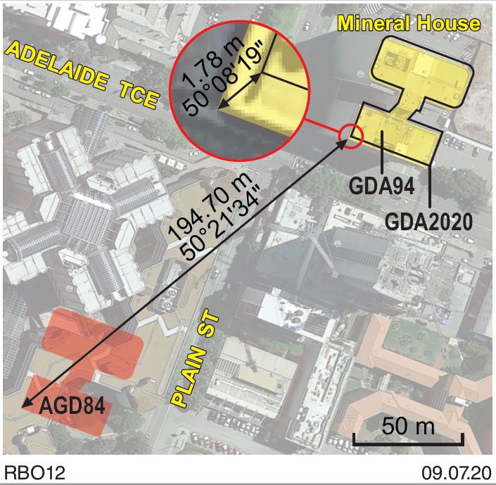
This map shows the location of Mineral House described in using three different datums: AGD84, GDA94 and GDA2020.
Australian Geodetic Datum 1984 (AGD84) was changed to Geodetic Datum of Australia (GDA94) in 2000 and resulted in an approximate 200m shift.
The shift to Geocentric Datum of Australia 2020 (GDA2020) is approximately 1.8m.
The buildings always stay in the same place relative to all other buildings and streets etc. The Datum changes represent the movement of the entire continent, requiring updates to the way the building location is described.